农业大数据学报 ›› 2026, Vol. 8 ›› Issue (2): 274-280.doi: 10.19788/j.issn.2096-6369.100073

• 数据资源 • 上一篇    

2019—2024年皖江平原冬闲田空间分布数据集

陈实1,3(), 黄银兰1,3, 邹金秋2,*()   

  1. 1 池州学院地理与规划学院安徽池州 247000
    2 中国农业科学院农业资源与农业区划研究所北京 100081
    3 池州学院农业生态资源与环境研究中心安徽池州 247000
  • 收稿日期:2025-12-30 接受日期:2026-03-09 出版日期:2026-06-26 发布日期:2026-06-26
  • 通讯作者: 邹金秋,E-mail: zoujinqiu@caas.cn
  • 作者简介:陈实,E-mail: shic11@126.com
  • 基金资助:
    安徽省哲学社会科学规划项目(AHSKQ2021D172)

Spatial Distribution Dataset of Winter Fallow Fields in the Wanjiang Plain (2019-2024)

CHEN Shi1,3(), HUANG YinLan1,3, ZOU JinQiu2,*()   

  1. 1 School of Geography and Planning, Chizhou University, Chizhou 247000, Anhui, China
    2 Institute of Agricultural Resources and Regional Planning, Chinese Academy of Agricultural Sciences, Beijing 100081, China
    3 Research Center for Agricultural Ecological Resources and Environment, Chizhou University, Chizhou 247000, Anhui, China
  • Received:2025-12-30 Accepted:2026-03-09 Published:2026-06-26 Online:2026-06-26

摘要:

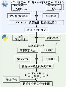
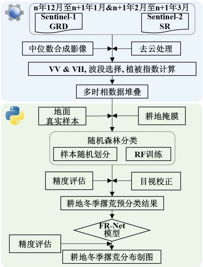
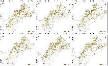
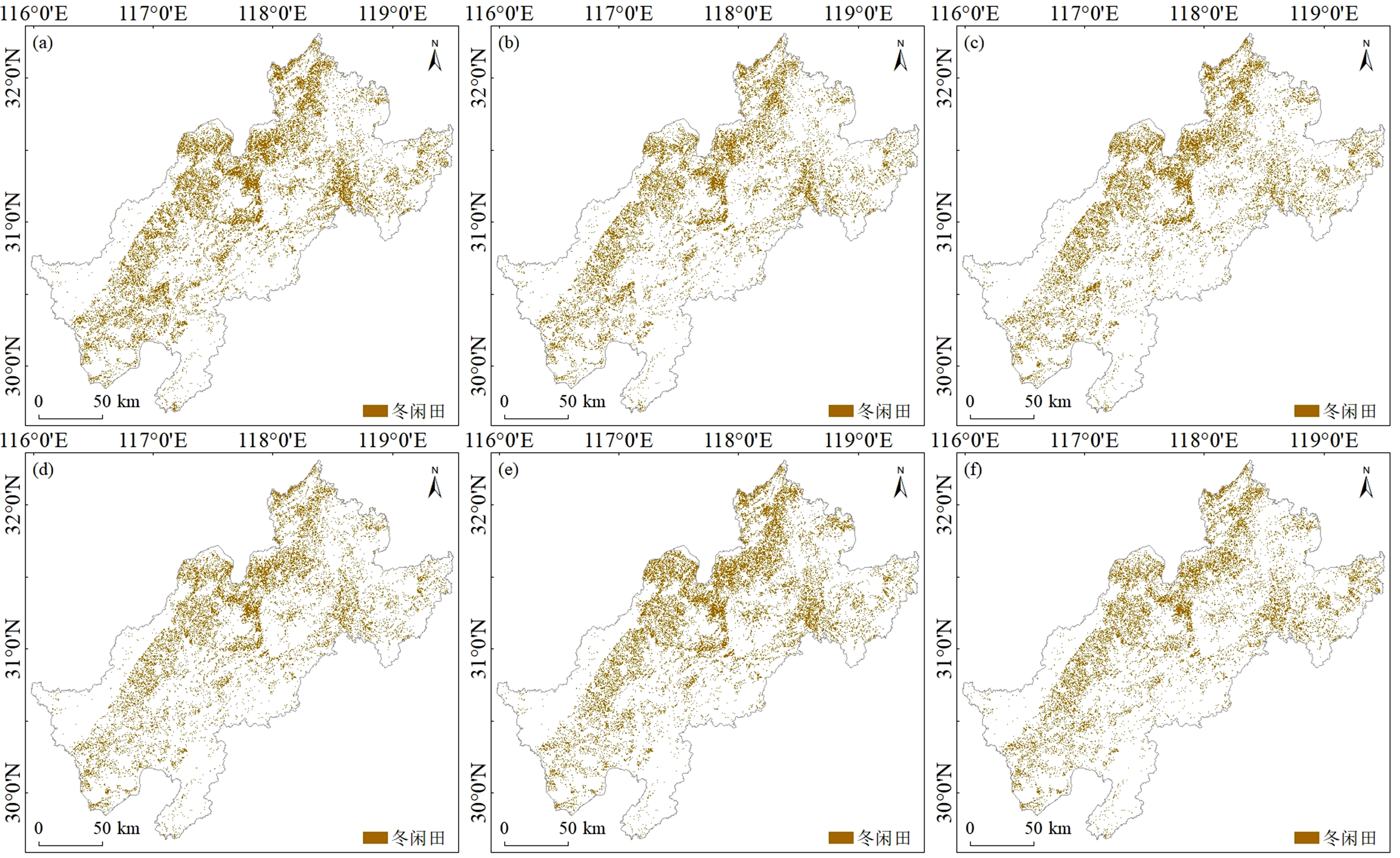
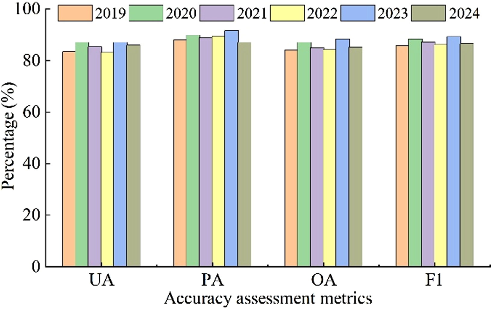
耕地资源的高效利用是保障国家粮食安全和促进农业可持续发展的基石。皖江平原作为长江经济带的重要粮食生产基地,具有典型的稻—麦、稻—油两熟制种植传统。然而,受农村劳动力转移、种植效益波动及气候变化等因素影响,该区域冬闲田现象日益频发。由于皖江平原冬季多云雨、地块破碎且种植结构复杂,传统基于单一光学遥感或中低分辨率影像的监测手段难以精准识别细碎的冬闲田地块,导致缺乏高精度、长时序的专题数据集,限制了对区域耕地利用效率的科学评估。本研究基于Google Earth Engine(GEE)云平台,构建了2019—2024年多源遥感协同观测数据集。首先,选取每年冬季关键物候期的Sentinel-1合成孔径雷达(SAR)与Sentinel-2光学影像,提取SAR后向散射系数(VV/VH)、光谱波段及归一化植被指数(NDVI)构建多维特征立方体,以克服云层干扰并捕捉物候特征。其次,基于352个冬闲田样本与325个非冬闲田样本,采用“随机森林(RF)预分类 + 边缘细化网络(FR-Net)”的级联制图策略。利用RF模型生成初始概率图,再通过引入残差结构的FR-Net深度学习模型进行语义分割与边缘优化,有效解决了破碎地块的边界模糊问题。本数据集包含2019年至2024年逐年的皖江平原冬闲田空间分布栅格数据,空间分辨率为10 m,坐标系为WGS 1984 UTM Zone 50N。数据结果显示,研究区冬季撂荒现象广泛且持续。经独立样本验证,本数据集的六年平均F1分数为87.21%,总体精度(OA)为85.64%,具有较高的制图精度与空间一致性。该数据可直接服务于农业部门的冬闲田开发利用规划、粮食产能潜力估算以及农田生态系统碳循环研究,为区域农业种植结构调整与政策制定提供可靠的数据支撑。

数据摘要:

项目 描述
数据库(集)名称 2019—2024年皖江平原冬闲田空间分布数据集
所属学科 农业科学
研究主题 冬闲田
数据时间范围 2019—2024年
时间分辨率
数据地理空间覆盖 安徽省皖江平原(30°0′N—32°0′N, 116°0′E—119°0′E)涵盖安庆、池州、铜陵、芜湖、马鞍山等沿江市县,总面积约3.72万km2
空间分辨率 10 m
数据类型与技术格式 .tif
数据库(集)组成 本数据集包含安徽省皖江平原2019—2024年每年10 m 空间分辨率冬闲田空间分布数据,每年对应1个tif 文件,共计6条记录。
数据量 417 MB
数据可用性 CSTR:17058.11.sciencedb.agriculture.00298; https://cstr.cn/17058.11.sciencedb.agriculture.00298
DOI:10.57760/sciencedb.agriculture.00298; https://doi.org/10.57760/sciencedb.agriculture.00298
经费支持 安徽省哲学社会科学规划项目(AHSKQ2021D172)。

关键词: 冬闲田, 皖江平原, Sentinel-1/2, FR-Net, 深度学习, 闲田利用

Abstract:

The efficient utilization of cropland resources serves as the cornerstone for safeguarding national food security and promoting sustainable agricultural development. As a pivotal grain production base within the Yangtze River Economic Belt, the Wanjiang Plain is characterized by traditional double-cropping systems, specifically rice-wheat and rice-rapeseed rotations. However, influenced by factors such as rural labor migration, fluctuating agricultural profitability, and climate change, the phenomenon of winter fallow fields (WFF) has become increasingly prevalent in this region. Due to frequent cloud cover and rain during winter, landscape fragmentation, and complex planting structures in the Wanjiang Plain, traditional monitoring methods relying on single-source optical remote sensing or coarse-resolution imagery struggle to accurately identify fragmented fallow parcels. This has resulted in a scarcity of high-precision, long-time-series thematic datasets, thereby constraining the scientific assessment of regional cropland utilization efficiency. Leveraging the Google Earth Engine (GEE) cloud platform, this study constructed a multi-source remote sensing collaborative observation dataset spanning from 2019 to 2024. First, Sentinel-1 Synthetic Aperture Radar (SAR) and Sentinel-2 optical imagery corresponding to key winter phenological stages were selected. A multi-dimensional feature cube was constructed by extracting SAR backscatter coefficients (VV/VH), spectral bands, and the Normalized Difference Vegetation Index (NDVI) to effectively mitigate cloud interference and capture distinct phenological characteristics. Second, based on 352 winter fallow field samples and 325 non-winter fallow field samples, a cascaded mapping strategy integrating "Random Forest (RF) pre-classification + Fine Resolution Network (FR-Net)" was employed. The RF model was utilized to generate initial probability maps, followed by the application of the FR-Net deep learning model—incorporating residual structures—for semantic segmentation and edge refinement. This approach effectively resolved boundary ambiguity issues common in fragmented parcels. This dataset comprises annual raster data of the spatial distribution of winter fallow fields in the Wanjiang Plain from 2019 to 2024, with a spatial resolution of 10 m and a coordinate system of WGS 1984 UTM Zone 50N. Results indicate that the winter fallow phenomenon in the study area is both extensive and persistent. Validated against independent samples, the dataset achieves a six-year average F1-score of 87.21% and an Overall Accuracy (OA) of 85.64%, demonstrating high mapping accuracy and spatial consistency. This dataset can directly support agricultural departments in planning the development and utilization of winter fallow fields, estimating grain production potential, and researching the cropland ecosystem carbon cycle. It provides reliable data support for regional agricultural planting structure adjustment and policy formulation.

Data summary:

Items Description
Dataset name Spatial Distribution Dataset of Winter Fallow Fields in the Wanjiang Plain (2019-2024)
Specific subject area Agricultural Science
Research topic Winter Fallow Fields
Time range 2019—2024
Temporal resolution Year
Geographical scope The Wanjiang Plain in Anhui Province (30°0′N-32°0′N, 116°0′E-119°0′E) covers along the river counties and cities, including Anqing, Chizhou, Tongling, Wuhu, and Ma'anshan, with a total area of approximately 37,200 km2.
Spatial resolution 10 m
Data types and technical formats .tif
Dataset structure This dataset contains the spatial distribution data of winter fallow farmland in the Wanjiang Plain of Anhui Province from 2019 to 2024, with a spatial resolution of 10 m for each year. Each year corresponds to one TIFF file, resulting in a total of six records.
Volume of dataset 417 MB
Data accessibility CSTR:17058.11.sciencedb.agriculture.00298; https://cstr.cn/17058.11.sciencedb.agriculture.00298
DOI:10.57760/sciencedb.agriculture.00298; https://doi.org/10.57760/sciencedb.agriculture.00298
Financial support The Philosophy and Social Science Planning Project of Anhui Province, China (Grant No. AH-SKQ2021D172).

Key words: winter fallow fields, Wanjiang plain, sentinel-1/2, FR-Net, deep learning, utilization of fallow land