农业大数据学报 ›› 2026, Vol. 8 ›› Issue (3): 281-295.doi: 10.19788/j.issn.2096-6369.000161
• 数据处理与分析 • 下一篇
王政锋1( ), 李莉2, 马瑞升3, 莫妘捷4, 匡昭敏3,*()
收稿日期:2026-04-26
接受日期:2026-07-15
出版日期:2026-09-26
发布日期:2026-10-08
通讯作者:
匡昭敏,E-mail:kzhaomin@163.com。作者简介:王政锋,E-mail: zfwang@glut.edu.cn。
基金资助:
WANG ZhengFeng1(), LI Li2, MA RuiSheng3, MO YunJie4, KUANG ZhaoMin3,*()
Received:2026-04-26
Accepted:2026-07-15
Published:2026-09-26
Online:2026-10-08
摘要:
针对单一气象指标为主要依据的干旱评估与预警方法难以精细化反映甘蔗生长状况的问题,研究构建了一种融合低空遥感影像与深度学习模型的甘蔗干旱等级智能识别方法。以健康/干旱甘蔗为研究对象,在三个典型种植区域采集地块低空遥感影像,计算归一化植被指数,并结合专家判读建立干旱等级标签。在U-Net语义分割框架基础上,引入残差网络ResNet-34作为主干,并采用加权跳跃连接提升边缘识别能力,构建了CaneUNet-W模型。通过区域交叉验证评估模型性能,结果显示模型在甘蔗地块识别任务中的交并比(IoU)、F1值和Kappa系数平均分别为0.924、0.960和0.912,表现出较高的精度与泛化能力,模型推演结果的空间分布特征与专家基于高分影像的视觉判读趋势基本吻合。本方法能客观反映甘蔗冠层在干旱胁迫下的遥感表型变异,验证了其在甘蔗旱情智能识别与精细化评估中的可行性与有效性。但受限于地面同步实测数据的缺乏,未来研究将引入土壤墒情等生理指标进行定量标定,从而提升甘蔗生产的防灾减灾能力。
王政锋, 李莉, 马瑞升, 莫妘捷, 匡昭敏. 甘蔗干旱等级识别的低空遥感分割模型研究[J]. 农业大数据学报, 2026, 8(3): 281-295.
WANG ZhengFeng, LI Li, MA RuiSheng, MO YunJie, KUANG ZhaoMin. Research on a Low-Altitude Remote Sensing Segmentation Model for Sugarcane Drought Level Identification[J]. Journal of Agricultural Big Data, 2026, 8(3): 281-295.
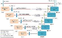
图1
模型CaneUNet-W结构示意图"
表1
模型结构参数设置表(以输入图像尺寸为512×512为例)"
| 模块 | 名称 | 操作类型 | 输出尺寸(H×W×C) | 参数说明 |
|---|---|---|---|---|
| 编码器 | Enc1 | Conv3×3+BN+ReLU×2 | 512×512×64 | ResNet-34 第1层 |
| Enc2 | Conv3×3+BN+ReLU×2 | 256×256×64 | MaxPool + ResNet-34 第2层 | |
| Enc3 | Conv3×3+BN+ReLU×2 | 128×128×128 | ResNet-34 第3层 | |
| Enc4 | Conv3×3+BN+ReLU×2 | 64×64×256 | ResNet-34 第4层 | |
| Enc5 | Conv3×3+BN+ReLU×2 | 32×32×512 | ResNet-34 第5层 | |
| 解码器 | UpConv5 | Transposed Conv 2×2 | 64×64×256 | 与 Enc4 特征相加融合 |
| UpConv4 | Transposed Conv 2×2 | 128×128×128 | 与 Enc3 特征相加融合 | |
| UpConv3 | Transposed Conv 2×2 | 256×256×64 | 与 Enc2 特征相加融合 | |
| UpConv2 | Transposed Conv 2×2 | 512×512×64 | 与 Enc1 特征相加融合 | |
| UpConv1 | Conv3×3+BN+ReLU | 512×512×32 | 最后融合层 | |
| 输出层 | OutputConv | Conv1×1+Sigmoid | 512×512×1 | 二分类概率图(甘蔗/非甘蔗)输出 |
表2
干旱等级划分标准"
| 干旱等级 | NDVI阈值区间 | 作物状态描述 |
|---|---|---|
| Level 0 | NDVI>0.70 | 无明显缺水迹象 |
| Level 1 | 0.50≤NDVI≤0.70 | 轻度水分不足,叶片色泽略暗 |
| Level 2 | 0.35≤NDVI<0.50 | 明显干旱,叶片卷曲发黄 |
| Level 3 | 0.20≤NDVI<0.35 | 重度干旱,叶片明显干枯 |
| Level 4 | NDVI<0.20 | 严重干旱,生长停滞或枯死 |
表3
区域交叉实验设计方案"
| 实验编号 | 训练区域 | 测试区域 |
|---|---|---|
| 实验一 | A区+B区 | C区 |
| 实验二 | B区+C区 | A区 |
| 实验三 | A区+C区 | B区 |
图2
三组区域交叉验证实验中模型的性能评估结果。评价指标包括IoU、mIoU、F1-score、Precision、Recall和Kappa系数。每组实验使用两个区域的数据训练模型,并在剩余区域进行测试。左图(柱状图)显示各指标得分;右图(ROC曲线)展示分类性能及AUC值。"
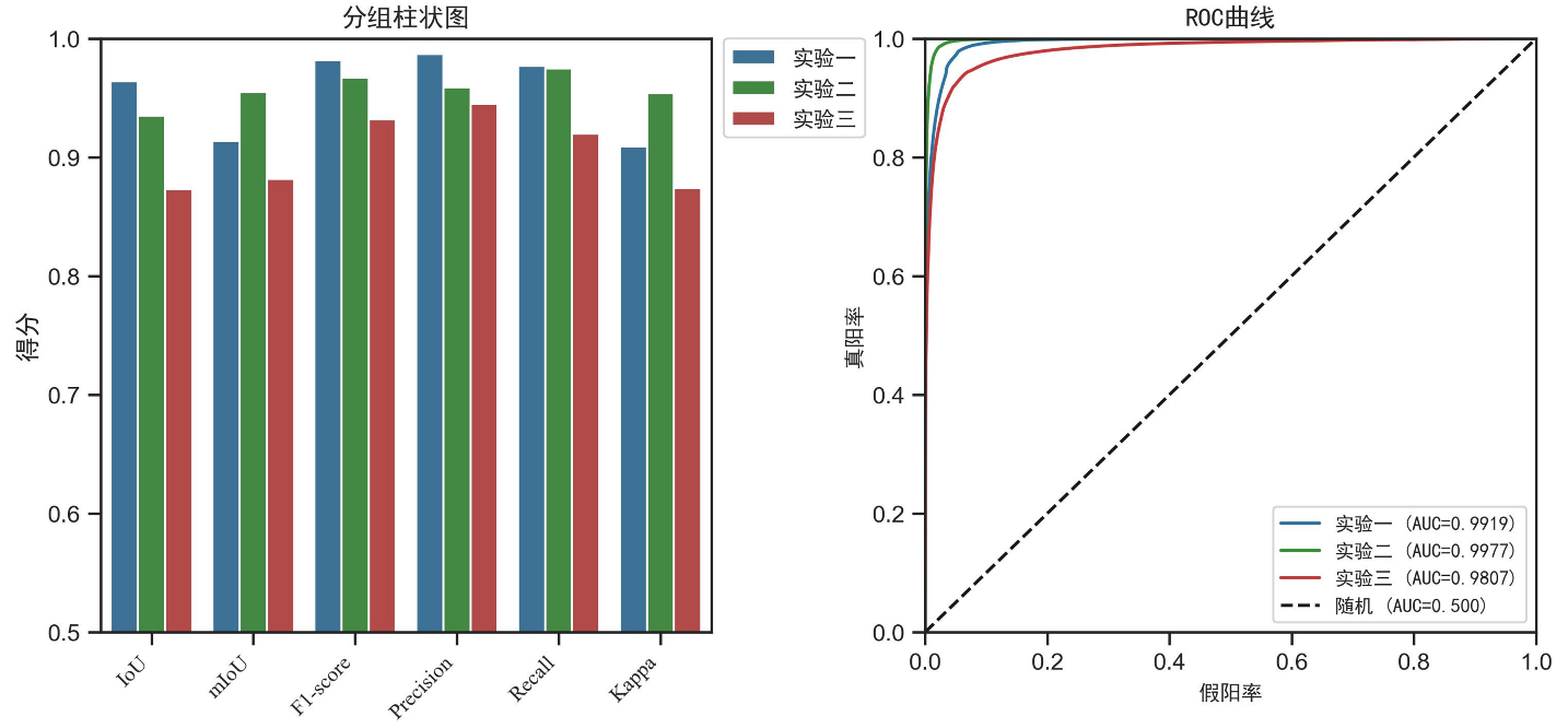
表4
不同测试区域的模型性能评价指标值"
| 实验编号 | IoU | mIoU | F1-score | Precision | Recall | Kappa |
|---|---|---|---|---|---|---|
| 实验一 | 0.964 | 0.914 | 0.982 | 0.987 | 0.977 | 0.909 |
| 实验二 | 0.935 | 0.955 | 0.967 | 0.959 | 0.975 | 0.954 |
| 实验三 | 0.873 | 0.882 | 0.932 | 0.945 | 0.920 | 0.874 |
图3
研究区分布与实验性能对比:标注了三个实验区域的地理位置及模型表现。A 区表现最佳(mIoU=0.955,Kappa=0.954),B区表现相对较低(mIoU=0.882,Kappa=0.874),C区地势平坦、采集时间较晚,其mIoU和Kappa略低。图示直观揭示地形与物候差异对模型识别精度的影响。"
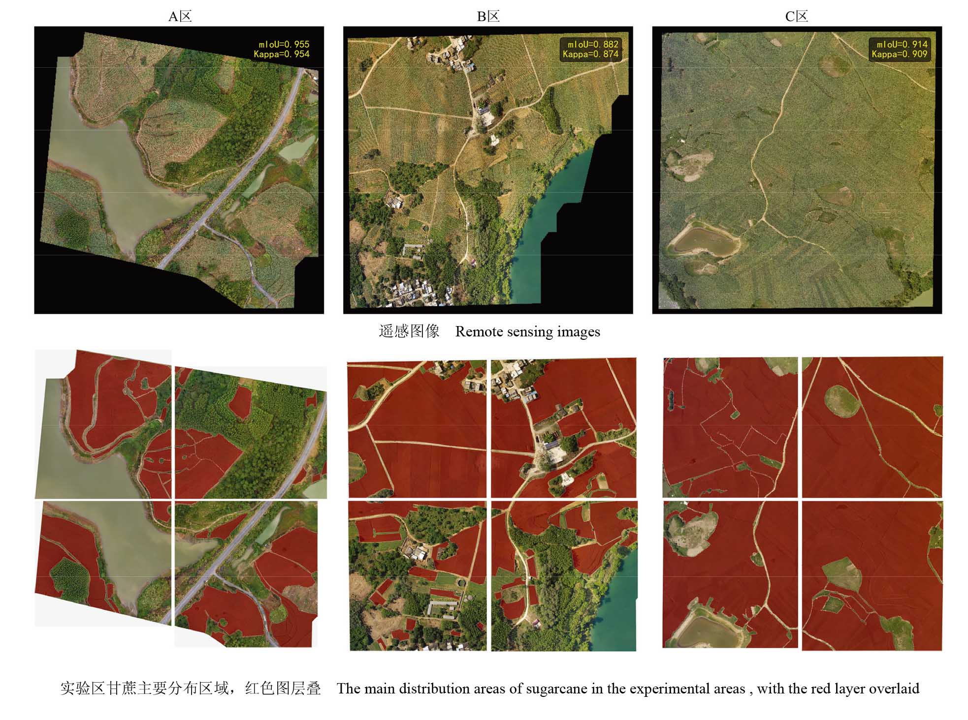
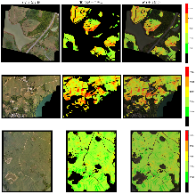
图4
典型测试区域甘蔗地分割及干旱等级预测可视化示例。左列为无人机原始影像,中列为预测干旱等级,右列为叠加结果。直观展示了模型对甘蔗地块边缘的精准识别,以及利用NDVI物理指标对干旱空间状态的客观精细化表征。"
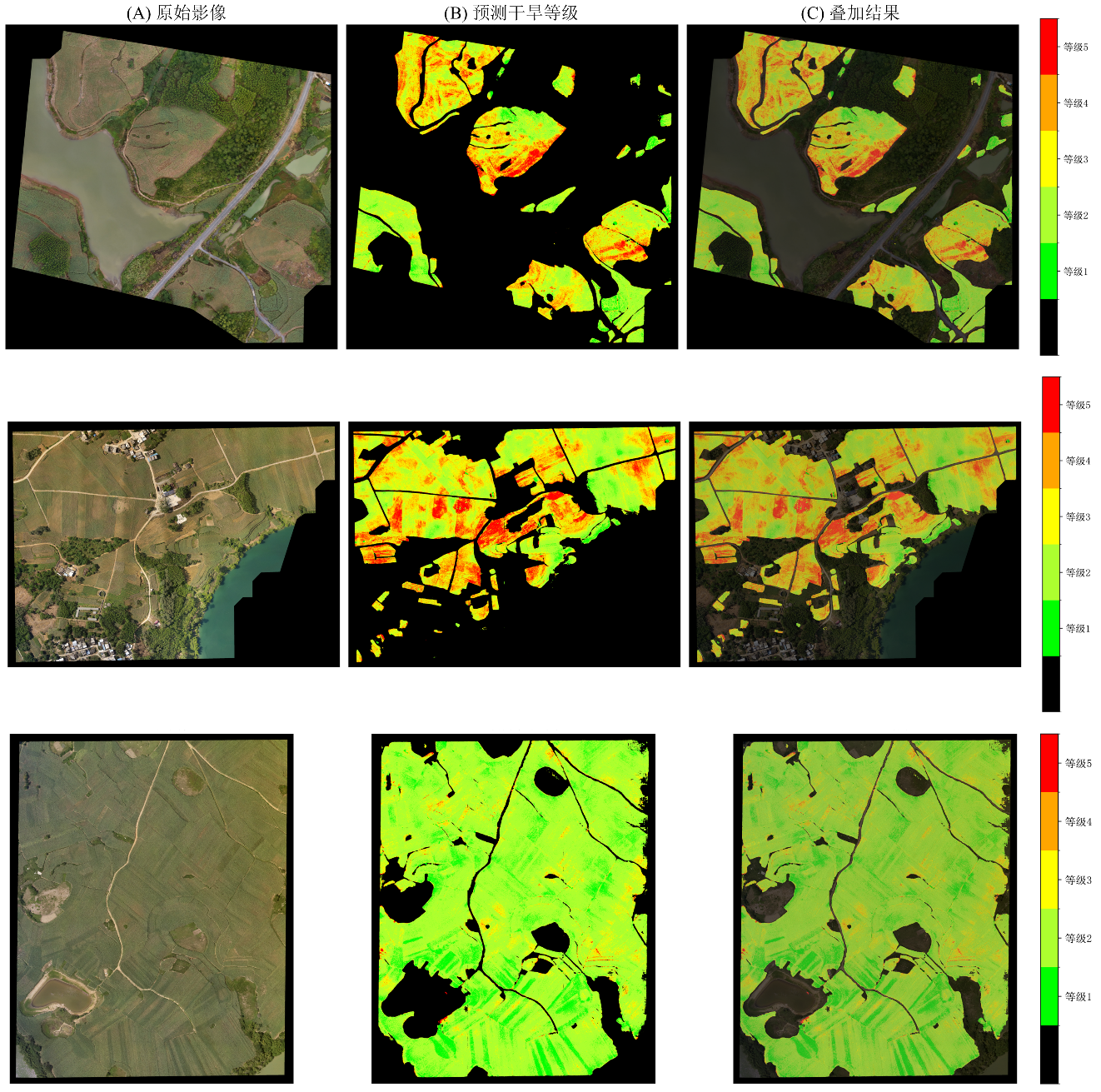
表5
不同模型在甘蔗地识别任务中的性能比较"
| 模型 | IoU | mIoU | F1-score | Precision | Recall | Kappa | Time (s) |
|---|---|---|---|---|---|---|---|
| U-Net | 0.814 | 0.683 | 0.898 | 0.988 | 0.822 | 0.618 | 18.24 |
| DeepLabv3+ | 0.969 | 0.925 | 0.984 | 0.987 | 0.982 | 0.921 | 21.99 |
| CaneUNet-W | 0.970 | 0.926 | 0.985 | 0.983 | 0.987 | 0.923 | 11.55 |
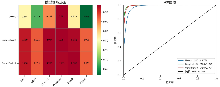
图5
模型CaneUNet-W在各个指标上与其它模型的对比以及三种模型的综合性能评估。评价指标包括IoU、mIoU、F1-score、Precision、Recall和Kappa系数。左图(热图)展示三种模型在各指标上的具体数值及整体性能差异;右图(ROC曲线图)显示三种模型的分类性能及AUC值。"
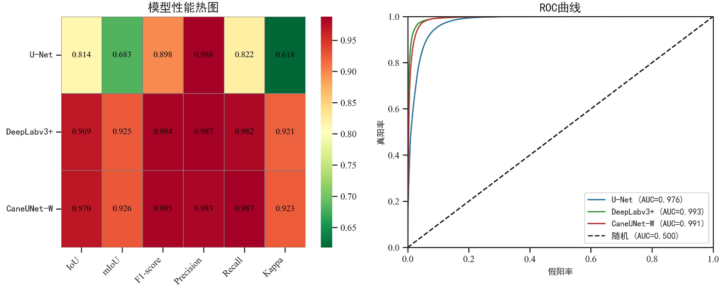
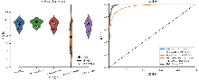
图6
模型性能评估与消融实验结果对比。改进型U-Net模型的五种消融模型在各评价指标(IoU、mIoU、F1-score、Precision、Recall、Kappa)上的性能分析。左图(小提琴-箱线-均值图)展示各模型在所有指标上的值分布、离散程度及均值对比;右图(ROC曲线图)显示五种模型的分类性能及对应 AUC值。"
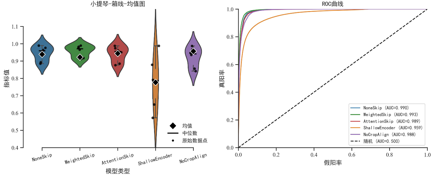
表6
消融实验结果对比"
| 模型版本 | IoU | mIoU | F1-score | Precision | Recall | Kappa |
|---|---|---|---|---|---|---|
| 无skip(NoneSkip) | 0.954 | 0.893 | 0.976 | 0.989 | 0.964 | 0.885 |
| 加权skip(WeightedSkip) | 0.965 | 0.917 | 0.982 | 0.989 | 0.976 | 0.912 |
| 注意力skip(AttentionSkip) | 0.950 | 0.885 | 0.974 | 0.988 | 0.961 | 0.876 |
| 浅层编码器(ShallowEncoder) | 0.783 | 0.649 | 0.878 | 0.988 | 0.791 | 0.572 |
| 无中心裁剪对齐(NoCropAlign) | 0.935 | 0.856 | 0.967 | 0.987 | 0.947 | 0.842 |
| [1] |
Sharma H, Sidhu H, Bhowmik A. Remote sensing using unmanned aerial vehicles for water stress detection: a review focusing on specialty crops. Drones, 2025, 9(4): 241.
doi: 10.3390/drones9040241 |
| [2] |
Chen H, Yang N, Song X, et al. A novel agricultural drought index based on multi-source remote sensing data and interpretable machine learning. Agricultural Water Management, 2025, 308: 109303.
doi: 10.1016/j.agwat.2025.109303 |
| [3] | 李欣璋, 别强, 石莹, 等. 中国西北地区不同类型草地NDVI对SPEI 的时空响应特征[J/OL]. 甘肃农业大学学报(2025-12-03). https://link.cnki.net/urlid/62.1055.s.20251202.2007.008. |
| Li X Z, Bie Q, Shi Y, et al. Spatiotemporal response characteristics of NDVI to SPEI in different grassland types in Northwest China[J/OL]. Journal of Gansu Agricultural University (2025-12-03). https://link.cnki.net/urlid/62.1055.s.20251202.2007.008. | |
| [4] |
Mullapudi A, Vibhute A D, Mali S, et al. A review of agricultural drought assessment with remote sensing data: Methods, issues, challenges and opportunities. Applied Geomatics, 2023, 15(1): 1-13.
doi: 10.1007/s12518-022-00484-6 |
| [5] |
Som-Ard J, Atzberger C, Izquierdo-Verdiguier E, et al. Remote sensing applications in sugarcane cultivation: A review. Remote Sensing, 2021, 13(20): 4040.
doi: 10.3390/rs13204040 |
| [6] | 李莉, 匡昭敏, 莫建飞, 等. 广西甘蔗秋旱灾害风险评估技术初步研究. 应用气象学报, 2016, 27(1): 95-101. |
| Li L, Kuang Z M, Mo J F, et al. Assessment of autumn drought risk of sugarcane in Guangxi. Journal of Applied Meteorological Science, 2016, 27(1): 95-101. | |
| [7] |
Kumar V, Sharma K V, Pham Q B, et al. Advancements in drought using remote sensing: assessing progress, overcoming challenges, and exploring future opportunities. Theoretical and Applied Climatology, 2024, 155(6): 4251-4288.
doi: 10.1007/s00704-024-04914-w |
| [8] |
Awais M, Li W, Cheema M J M, et al. UAV-based remote sensing in plant stress imagine using high-resolution thermal sensor for digital agriculture practices: A meta-review. International Journal of Environmental Science and Technology, 2023, 20(1): 1135-1152.
doi: 10.1007/s13762-021-03801-5 |
| [9] | 李林源, 黄华国, 穆西晗, 等. 低空无人机植被定量遥感:进展、挑战与展望. 遥感学报, 2025, 29(6): 2083-2113. |
|
Li L Y, Huang H G, Mu X H, et al. Low-altitude UAV-based quantitative remote sensing of vegetation: Advances, challenges, and prospects. National Remote Sensing Bulletin, 2025, 29(6): 2083-2113.
doi: 10.11834/jrs.20255048 |
|
| [10] | Mohd Nazri N W, Hashim K A, Mohd Zaki N A, et al. Advancing sustainable paddy farming: utilizing multispectral unmanned aerial vehicle (UAV) technology for efficient water stress detection and management//2025 21st IEEE International Colloquium on Signal Processing & Its Applications (CSPA). February 7-8, 2025: 210-215. |
| [11] | Aldrighettoni J, d'Urso M G. Advances in precision farming: a contribute for estimating crop health and water stress by comparing UAV multispectral and thermal imagery. ISPRS Annals of the Photogrammetry, Remote Sensing and Spatial Information Sciences, 2025: 33-40. |
| [12] |
Ahmad U, Alvino A, Marino S. A review of crop water stress assessment using remote sensing. Remote Sensing, 2021, 13(20): 4155.
doi: 10.3390/rs13204155 |
| [13] |
Ruwanpathirana P P, Sakai K, Jayasinghe G Y, et al. Evaluation of sugarcane crop growth monitoring using vegetation indices derived from RGB-based UAV images and machine learning models. Agronomy, 2024, 14(9): 2059.
doi: 10.3390/agronomy14092059 |
| [14] |
Dong H, Dong J H, Sun S K, et al. Crop water stress detection based on UAV remote sensing systems. Agricultural Water Management, 2024, 303: 109059.
doi: 10.1016/j.agwat.2024.109059 |
| [15] |
钱涛, 詹雅婷, 李胤, 等. 基于车载相机和HLS时序遥感数据的作物分类研究. 农业大数据学报, 2025, 7(2): 161-172.
doi: 10.19788/j.issn.2096-6369.000098 |
|
Qian T, Zhan Y T, Li Y, et al. Crop Classification research based on vehicle images and HLS time-series remote sensing data. Journal of Agricultural Big Data, 2025, 7(2): 161-172.
doi: 10.19788/j.issn.2096-6369.000098 |
|
| [16] |
Cai Z R, Liu Z Y, Kou L. Reliable UAV monitoring system using deep learning approaches. IEEE Transactions on Reliability, 2022, 71(2): 973-983.
doi: 10.1109/TR.2021.3119068 |
| [17] |
Bouguettaya A, Zarzour H, Kechida A, et al. Deep learning techniques to classify agricultural crops through UAV imagery: A review. Neural Computing and Applications, 2022, 34(12): 9511-9536.
doi: 10.1007/s00521-022-07104-9 |
| [18] |
Mittal P, Singh R, Sharma A. Deep learning-based object detection in low-altitude UAV datasets: A survey. Image and Vision Computing, 2020, 104: 104046.
doi: 10.1016/j.imavis.2020.104046 |
| [19] | 黄睿茜, 赵俊芳, 霍治国, 等. 深度学习技术在农业干旱监测预测及风险评估中的应用. 中国农业气象, 2023, 44(10): 943-952. |
| Huang R X, Zhao J F, Huo Z G, et al. Application of deep learning technology in monitoring,forecasting and risk assessment of agricultural drought. Chinese Journal of Agrometeorology, 2023, 44(10): 943-952. | |
| [20] |
苑江浩, 郑作军, 初昌明, 等. 2023年黑龙江水稻产量预测无人机遥感图像数据集. 农业大数据学报, 2024, 6(4): 546-551.
doi: 10.19788/j.issn.2096-6369.100031 |
|
Yuan J H, Zheng Z J, Chu C M, et al.Rice yield prediction UAV remote sensing image dataset of Heilongjiang province in 2023. Journal of Agricultural Big Data, 2024, 6(4): 546-551
doi: 10.19788/j.issn.2096-6369.100031 |
|
| [21] |
Osco L P, Junior J M, Ramos A P M, et al. A review on deep learning in UAV remote sensing. International Journal of Applied Earth Observation and Geoinformation, 2021, 102: 102456.
doi: 10.1016/j.jag.2021.102456 |
| [22] |
Shahi T B, Xu C Y, Neupane A, et al. Recent advances in crop disease detection using UAV and deep learning techniques. Remote Sensing, 2023, 15(9): 2450.
doi: 10.3390/rs15092450 |
| [23] |
Su J Y, Coombes M, Liu C J, et al. Machine learning-based crop drought mapping system by UAV remote sensing RGB imagery. Unmanned Systems, 2020, 8(1): 71-83.
doi: 10.1142/S2301385020500053 |
| [24] |
Prodhan F A, Zhang J, Yao F, et al. Deep learning for monitoring agricultural drought in south Asia using remote sensing data. Remote Sensing, 2021, 13(9): 1715.
doi: 10.3390/rs13091715 |
| [25] |
Yang X H, Gao F, Yuan H W, et al. Integrated UAV and satellite multi-spectral for agricultural drought monitoring of winter wheat in the seedling stage. Sensors, 2024, 24(17): 5715.
doi: 10.3390/s24175715 |
| [26] |
Liu C, Li H Y, Su A Y, et al. Identification and grading of maize drought on RGB images of UAV based on improved U-Net. IEEE Geoscience and Remote Sensing Letters, 2021, 18(2): 198-202.
doi: 10.1109/LGRS.8859 |
| [27] | 张淦, 严海峰, 胡根生, 等. 基于深度学习语义分割和迁移学习策略的麦田倒伏面积识别方法. 智慧农业(中英文), 2023, 5(3): 75-85. |
|
Zhang G, Yan H F, Hu G S, et al. Identification method of wheat field lodging area based on deep learning semantic segmentation and transfer learning. Smart Agriculture, 2023, 5(3): 75-85.
doi: 10.12133/j.smartag.SA202309013 |
|
| [28] |
Liang H, Zhou Y, Lu Y, et al. Evaluation of soybean drought tolerance using multimodal data from an unmanned aerial vehicle and machine learning. Remote Sensing, 2024, 16(11): 2043.
doi: 10.3390/rs16112043 |
| [29] |
Niu S W, Nie Z G, Li G, et al. Early drought detection in maize using UAV images and YOLOv8+. Drones, 2024, 8(5): 170.
doi: 10.3390/drones8050170 |
| [30] |
Zhou J, Zhou J F, Ye H, et al. Classification of soybean leaf wilting due to drought stress using UAV-based imagery. Computers and Electronics in Agriculture, 2020, 175: 105576.
doi: 10.1016/j.compag.2020.105576 |
| [1] | 陈实, 黄银兰, 邹金秋. 2019—2024年皖江平原冬闲田空间分布数据集[J]. 农业大数据学报, 2026, 8(2): 274-280. |
| [2] | 肖吟枫, 杨抒. AGLU-YOLO:轻量化柑橘叶片病害实时检测算法研究[J]. 农业大数据学报, 2026, 8(2): 141-154. |
| [3] | 赵晓燕, 周焕斌, 周国民, 张建华. 深度学习在作物基因编辑技术的应用与研究进展[J]. 农业大数据学报, 2026, 8(1): 24-35. |
| [4] | 叶端南, 李根田. 一种基于改进YOLO的小目标检测模型[J]. 农业大数据学报, 2025, 7(2): 173-182. |
| [5] | 刘洪, 窦婧文, 王越, 廖勇, 刘小磊, 李新云, 赵书红, 付玉华. 一种面向功能基因挖掘的动物多组学数据集[J]. 农业大数据学报, 2025, 7(1): 96-106. |
| [6] | 牛博文, 冯权泷, 张毓, 高秉博, SUKHBAATAR Chinzorig, 冯爱萍, 杨建宇. 2022年克鲁伦河流域10米分辨率植被覆盖度月度数据集[J]. 农业大数据学报, 2025, 7(1): 59-68. |
| [7] | 李佳乐, 张建华, 王健, 周国民. 数据驱动的农业深度学习方法计量分析[J]. 农业大数据学报, 2024, 6(3): 400-411. |
| [8] | 杜家宽, 李雁飞, 孙嗣文, 刘继东, 江腾达. 多源数据融合的泛时空特征水稻深度学习提取[J]. 农业大数据学报, 2024, 6(1): 56-67. |
| [9] | 毛克彪, 袁紫晋, 施建成, 武胜利, 胡德勇, 车进, 董立新. 基于大数据的遥感参数人工智能反演范式理论形成与工程技术实现[J]. 农业大数据学报, 2023, 5(4): 1-12. |
| [10] | 赵鸿鑫, 邵明月, 潘攀, 王芝奥, 牟强, 贺子康, 张建华. 一种面向深度神经网络模型的棉花常见病害训练数据集[J]. 农业大数据学报, 2023, 5(4): 47-55. |
| [11] | 张凌栩,韩锐,李文明,史银雪,刘驰. 大数据深度学习系统研究进展与典型农业应用[J]. 农业大数据学报, 2019, 1(2): 88-104. |
| [12] | 吴蕾,梁晓贺,乌吉斯古楞,王瑞. 基于词向量的检索扩展方法与农业领域实证[J]. 农业大数据学报, 2019, 1(2): 114-120. |
| [13] | 李贤江, 陈佑启, 邹金秋, 石淑芹, 郭涛, 蔡为民, 陈浩. 卷积神经网络在高分辨率影像分类中的应用[J]. 农业大数据学报, 2019, 1(1): 67-77. |
|
||
