农业大数据学报 ›› 2025, Vol. 7 ›› Issue (1): 69-76.doi: 10.19788/j.issn.2096-6369.100041

• “一带一路”沿线农业资源环境监测与分析专栏 • 上一篇    下一篇

1990-2022年蒙古国植被覆盖度数据集

杨梅焕1(), 李雅雯1,*(), 王涛2   

  1. 1.西安科技大学测绘科学与技术学院,西安 710054
    2.西安科技大学国土空间研究所,西安 710054
  • 收稿日期:2024-08-01 接受日期:2024-11-04 出版日期:2025-03-26 发布日期:2025-02-05
  • 通讯作者: 李雅雯,E-mail:893151469@qq.com
  • 作者简介:杨梅焕,E-mail:ymh8307024@163.com
  • 基金资助:
    国家重点研发计划项目(2022YFE0119200);国家自然科学基金资助项目(41977059);国家自然科学基金资助项目(41501571)

The 1990-2022 Mongolia Fractional Vegetation Cover Dataset

YANG MeiHuan1(), LI YaWen1,*(), WANG Tao2   

  1. 1. College of Surveying and Mapping Science and Technology, Xi'an University of Science and Technology, Xi’an 710054, China
    2. Institute of Land and Space Research, Xi'an University of Science and Technology, Xi’an 710054, China
  • Received:2024-08-01 Accepted:2024-11-04 Published:2025-03-26 Online:2025-02-05

摘要:

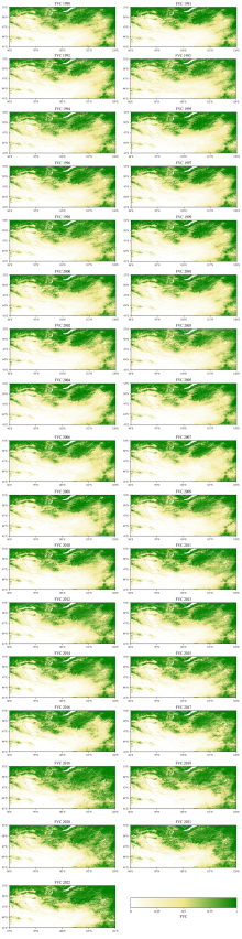
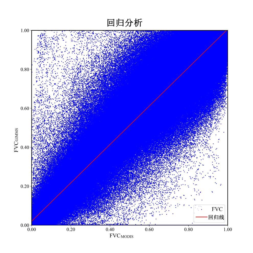
蒙古高原是我国北方重要生态屏障,蒙古国生态功能的稳定与健康对于深入了解全球气候变暖的区域植被响应特征及筑牢我国北方生态屏障具有重要的理论与现实意义。植被覆盖度(FVC)是指评估地表植被覆盖程度的指标,通常用于衡量植被对地表的覆盖情况,是评价草原生态系统健康的重要指标之一,对及时监测草原植被的变化情况、发现草原退化和恢复的趋势具有重要意义。植被覆盖度的变化直接影响土壤侵蚀和水土流失,监测和控制植被覆盖度有助于减缓土壤侵蚀速度,维护草原生态系统的稳定性。本研究旨在生成并验证1990年至2022年间空间分辨率为1/12°的年度FVC数据集,以反映长时间序列下蒙古国植被覆盖度空间分布情况。为确保数据集的准确性和可靠性,研究结合了MOD13Q1数据进行计算校准和验证,以确保FVC计算的精度。本研究通过植被覆盖度数据集的构建,为蒙古国草原生态系统的保护与管理提供了科学依据。

数据摘要:

项目 描述
数据集名称 1990-2022年蒙古国植被覆盖度数据集
所属学科 生态学
研究主题 植被覆盖度计算
数据时间范围 1990-2022
时间分辨率 1年
数据地理空间覆盖 (41°—53°N,87°—121°E)
空间分辨率 1/12°
数据类型与技术格式 .tiff
数据库(集)组成 数据集为1990-2022年年度蒙古国1/12°的植被覆盖度
数据量 7.47 MB
主要数据指标 NDVI、FVC
数据可用性 https://cstr.cn/17058.11.sciencedb.agriculture.00118
https://doi.org/10.57760/sciencedb.agriculture.00118
经费支持 国家重点研发计划项目(2022YFE0119200);国家自然科学基金项目(41977059, 41501571)

关键词: 蒙古国, 植被覆盖度, 时空分布

Abstract:

The Mongolian Plateau, a crucial ecological barrier in Northern China, necessitates stable and healthy ecological functions in Mongolia for understanding regional vegetation's response to global warming and reinforcing our northern ecological defenses. Fractional Vegetation Cover (FVC) is an indicator used to assess the extent of vegetation cover on the Earth's surface. It is commonly utilized to measure the coverage provided by vegetation, serving as a crucial metric for evaluating the health of grassland ecosystems. Monitoring changes in FVC is significant for promptly detecting trends in grassland degradation and recovery. Variations in FVC directly impact soil erosion and water loss, and monitoring and controlling FVC can help slow down soil erosion and maintain the stability of grassland ecosystems. This study aims to generate and validate an annual FVC dataset with a spatial resolution of 1/12° spanning from 1990 to 2022, with the objective of comprehensively reflecting the distribution of vegetation cover in Mongolia over an extended temporal series. To ensure the accuracy and reliability of the dataset, the study integrated MOD13Q1 data for computational calibration and validation, thereby guaranteeing the precision of FVC calculations. By constructing this FVC dataset, the study provides a scientific basis for the conservation and management of the grassland ecosystem in Mongolia.

Data summary:

Item Description
Dataset name The 1990-2022 Mongolia Fractional Vegetation Cover Dataset
Specific subject area Ecology
Research topic Vegetation Monitoring and Analysis
Time range 1990-2022
Temporal resolution 1 year
Geographical scope (41°—53°N,87°—121°E)
Spatial resolution 1/12°
Data types and technical formats .tiff
Dataset structure The dataset is the annual 1/12°vegetation coverage of Mongolia from 1990 to 2022.
Volume of dataset 7.47 MB
Key index in dataset NDVI, FVC
Data accessibility https://cstr.cn/17058.11.sciencedb.agriculture.00118
https://doi.org/10.57760/sciencedb.agriculture.00118
Financial support The National Key Research and Development Program project (2022YFE0119200); National Natural Science Foundation of China projects (41977059, 41501571).

Key words: Mongolia, vegetation coverage, spatiotemporal distribution