
Journal of Agricultural Big Data ›› 2026, Vol. 8 ›› Issue (2): 183-198.doi: 10.19788/j.issn.2096-6369.000119
Previous Articles Next Articles
ZHAO Yan1( ), LI Xia1,*(), FENG JianZhong2,*(), GUO JingLi3, XIE NengFu2, XUE Yuan2
Received:2025-06-09
Accepted:2025-09-28
Online:2026-06-26
Published:2026-06-26
Contact:
LI Xia, FENG JianZhong
ZHAO Yan, LI Xia, FENG JianZhong, GUO JingLi, XIE NengFu, XUE Yuan. Spatiotemporal Pattern Dynamics of Cultivated Land in the Transitional Zone of Cropping System, Northern China, Based on Multi-source Data from Google Earth Engine, and Coping Strategy[J].Journal of Agricultural Big Data, 2026, 8(2): 183-198.
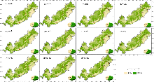
Fig. 1
Spatial distribution map of cultivated land resources in the study area from 2000 to 2020"

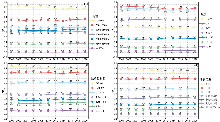
Fig. 2
Different topographic distribution indices of cultivated land in the study area from 2000 to 2020"

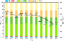
Fig. 3
Time change diagram of the cultivated land in the study area and proportion of cultivated land in provinces and cities from 2000 to 2020"
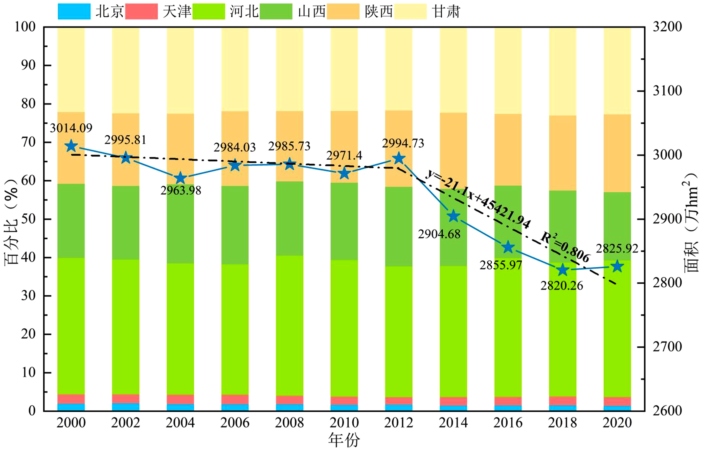
Fig. 4
Location and moving direction of cultivated land gravity center in the study area from 2000 to 2020"
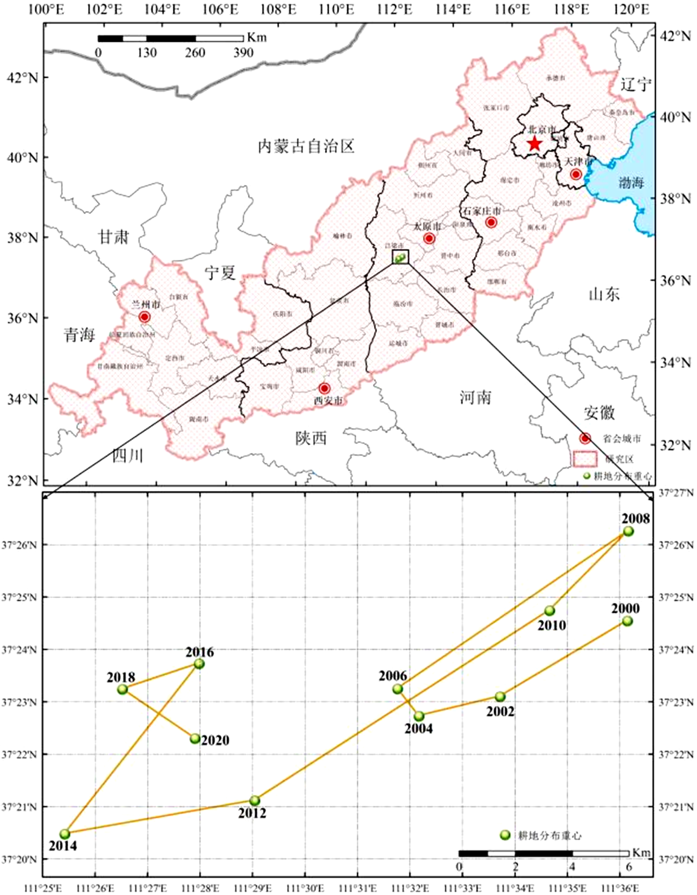
Fig. 5
Dynamic degree of cultivated land use in the study area and provinces from 2000 to 2020"
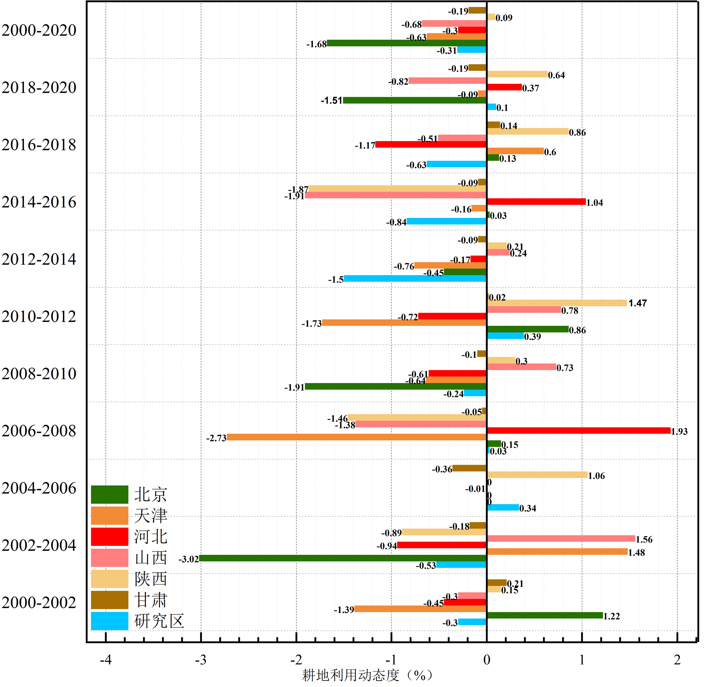
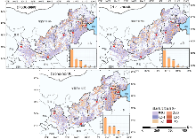
Fig. 6
Spatial distribution of dynamic degree of cultivated land use in study area and provinces in different periods"

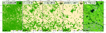
Fig. 7
Classification results of the dominant area of cultivated land by different methods"

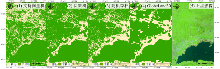
Fig. 8
Classification results of the forestland dominant area by different methods"
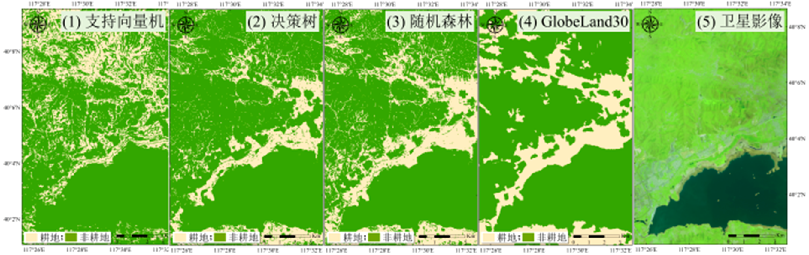
Fig. 9
Identification accuracy of cultivated land information in the study area from 2000 to 2020 based on confusion matrix"
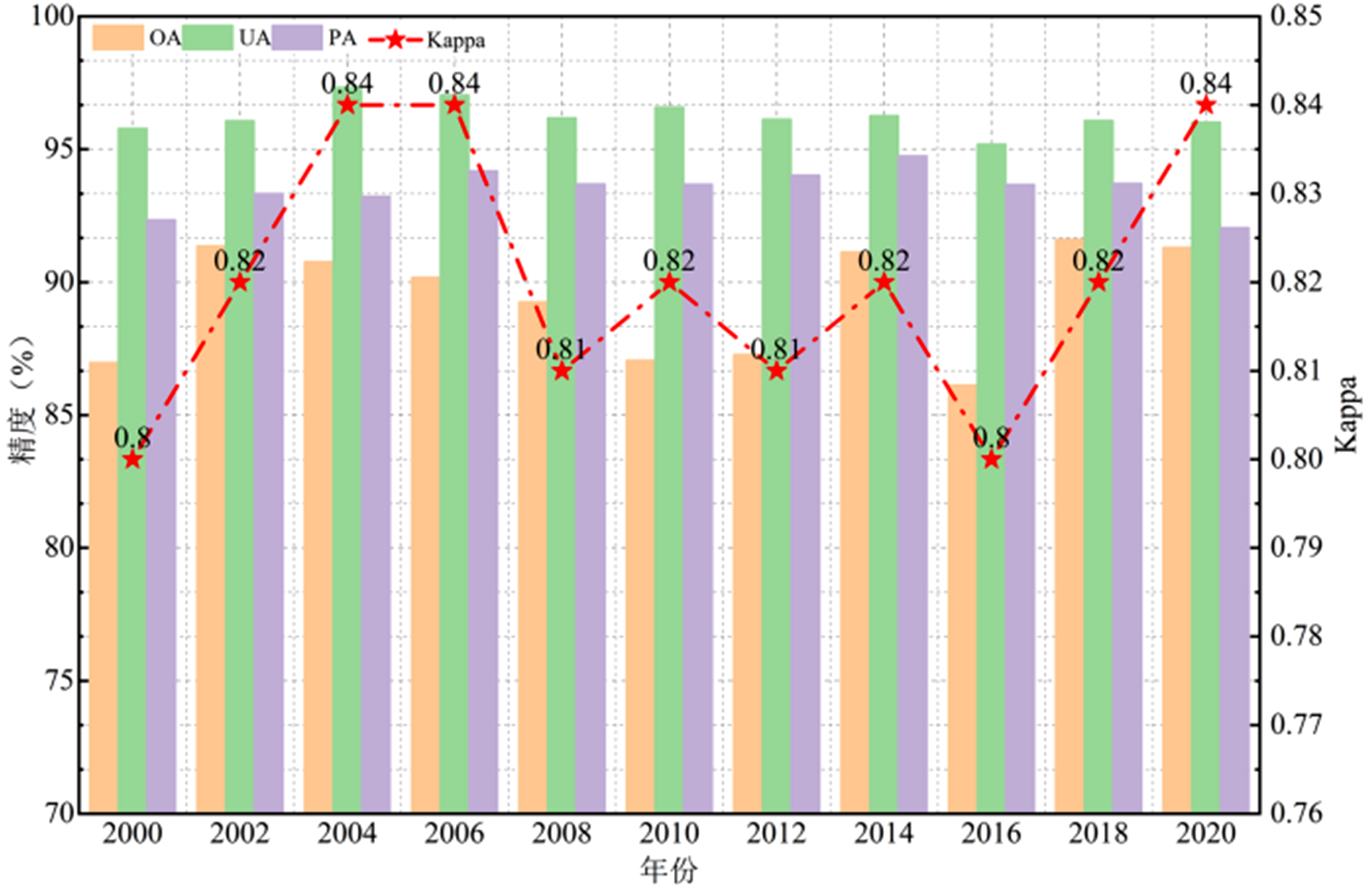
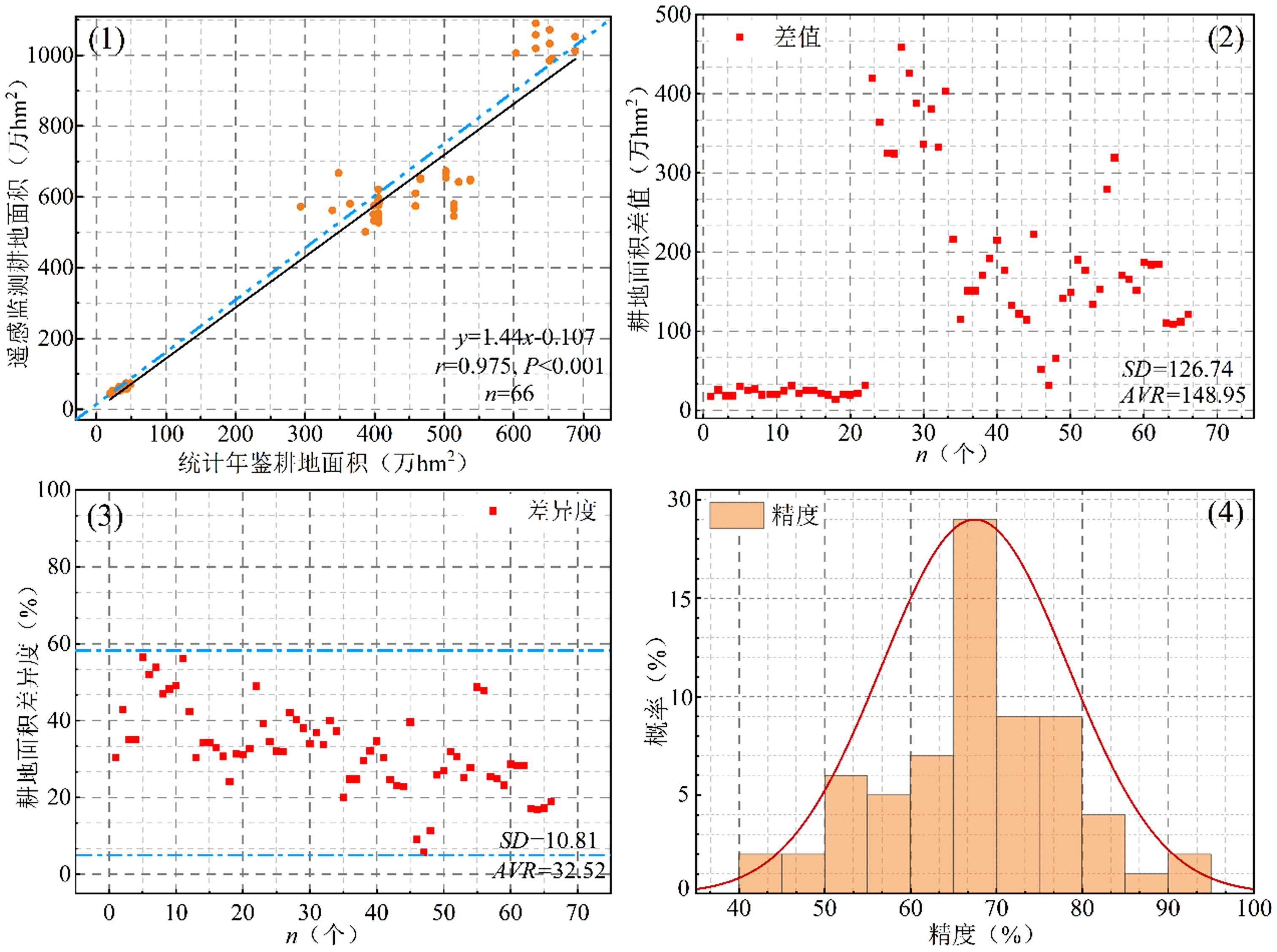
Fig. 10
Identification accuracy of cultivated land information in the study area from 2000 to 2020 based on statistical data"
| [1] |
张瑞, 杜国明, 张树文. 1986—2020年东北典型黑土区耕地资源时空变化及其驱动因素. 资源科学, 2023, 45(5): 939-950.
doi: 10.18402/resci.2023.05.05 |
|
ZHANG R, DU G M, ZHANG S W. Spatiotemporal changes and the driving factors of cultivated land resources of the typical black soil region in Northeast China from 1986 to 2020. Resources Science, 2023, 45(5): 939-950.
doi: 10.18402/resci.2023.05.05 |
|
| [2] |
张颖诗, 冯艳芬, 王芳, 等. 广东省耕地非粮化的时空分异及其驱动机制. 资源科学, 2022, 44(3): 480-493.
doi: 10.18402/resci.2022.03.05 |
|
ZHANG Y S, FENG Y F, WANG F, et al. Spatiotemporal differentiation and driving mechanism of cultivated land non-grain conversion in Guangdong Province. Resources Science, 2022, 44(3): 480-493.
doi: 10.18402/resci.2022.03.05 |
|
| [3] |
钟礼山, 李满春, 伍阳, 等. 利用SAR影像时间序列的耕地提取研究. 地理科学进展, 2015, 34(7): 830-839.
doi: 10.18306/dlkxjz.2015.07.005 |
|
ZHONG L S, LI M C, WU Y, et al. Cropland extraction using SAR time series image. Progress in Geography, 2015, 34(7): 830-839.
doi: 10.18306/dlkxjz.2015.07.005 |
|
| [4] | 巫志雄, 李乔宇, 王宗良, 等. 遥感影像耕地提取的研究进展与展望. 山东农业科学, 2024, 56(12): 163-170. |
| WU Z X, LI Q Y, WANG Z L, et al. Research progress and prospect of cultivated land extraction from remote sensing images. Shandong Agricultural Sciences, 2024, 56(12): 163-170. | |
| [5] | 熊曦柳, 胡月明, 文宁, 等. 耕地遥感识别研究进展与展望. 农业资源与环境学报, 2020, 37(6): 856-865. |
| XIONG X L, HU Y M, WEN N, et al. Progress and prospect of cultivated land extraction research using remote sensing. Journal of Agricultural Resources and Environment, 2020, 37(6): 856-865. | |
| [6] | 李宗梅, 满旺, 聂芹, 等. 基于遥感的耕地信息提取研究进展. 安徽农业科学, 2016, 44(31): 242-244. |
| LI Z M, MAN W, NIE Q, et al. Research advances of cultivated land information extraction based on remote sensing. Journal of Anhui Agricultural Sciences, 2016, 44(31): 242-244. | |
| [7] |
FRIEDL M A, SULLA-MENASHE D, TAN B, et al. MODIS collection 5 global land cover: Algorithm refinements and characterization of new datasets. Remote Sensing of Environment, 2010, 114(1): 168-182.
doi: 10.1016/j.rse.2009.08.016 |
| [8] |
GONG P, WANG J, YU L, et al. Finer resolution observation and monitoring of global land cover: First mapping results with Landsat TM and ETM+ data. International Journal for Remote Sensing, 2013, 34(7/8): 2607-2654.
doi: 10.1080/01431161.2012.748992 |
| [9] | 刘睿, 王志勇, 高瑞. 时序SAR影像的干旱地区土地利用分类应用. 测绘科学, 2021, 46(10): 90-97. |
| LIU R, WANG Z Y, GAO R. Application of time series SAR image in land use classification in arid area. Science of Surveying and Mapping, 2021, 46(10): 90-97. | |
| [10] | 付博, 雷宇阳, 任春颖. 基于Google Earth Engine和Sentinel-1/2影像的吉林省耕地逐年动态变化分析. 吉林师范大学学报(自然科学版), 2025, 46(3): 124-134. |
| FU B, LEI Y Y, REN C Y. Analysis of annual dynamic changes in cropland in Jilin Province based on Google Earth Engine and Sentinel-1 /2 imagery. Journal of Jilin Normal University (Natural Science Edition), 2025, 46(3): 124-134. | |
| [11] |
麦晶晶, 冯琦胜, 王瑞泾, 等. 基于机器学习的高精度耕地识别模型构建——以甘肃省张掖市为例. 草业学报, 2025, 34(2): 149-162.
doi: 10.11686/cyxb2024110 |
| MAI J J, FENG Q S, WANG R J, et al. Construction of a high-precision cultivated land identification model based on machine learningusing Zhangye City, Gansu Province as an example. Acta Prataculturae Sinica, 2025, 34(2): 149-162. | |
| [12] | 颜玲, 李少达, 李彩瑛, 等. 基于GF-2遥感影像和改进后PSPNet模型的丘陵地区耕地图斑提取方法. 成都理工大学学报(自然科学版), 2024, 51(2): 269-280. |
| YAN L, LI S D, LI C Y, et al. Extracting patches of arable land in hilly areas based on GF-2 remote sensing images and an improved PSPNet model. Journal of Chengdu University of Technology (Science& Technology Edition), 2024, 51(2): 269-280. | |
| [13] |
ZHANG D J, PAN Y Z, ZHANG J S, et al. A generalized approach based on convolutional neural networks for large area cropland mapping at very high resolution. Remote Sensing of Environment, 2020, 247: 111912.
doi: 10.1016/j.rse.2020.111912 |
| [14] |
MCCARTY J L, NEIGH C S R, CARROLL M L, et al. Extracting smallholder cropped area in Tigray, Ethiopia with wall-to-wall sub-meter WorldView and moderate resolution Landsat 8 imagery. Remote Sensing of Environment, 2017, 202: 142-151.
doi: 10.1016/j.rse.2017.06.040 |
| [15] |
RABIEI S, JALILVAND E, TAJRISHY M. A method to estimate surface soil moisture and map the irrigated cropland area using Sentinel-1 and Sentinel-2 data. Sustainability, 2021, 13(20):11355.
doi: 10.3390/su132011355 |
| [16] |
ZHAO W Z, QU Y, CHEN J, et al. Deeply synergistic optical and SAR time series for crop dynamic monitoring. Remote Sensing of Environment, 2020, 247: 111952.
doi: 10.1016/j.rse.2020.111952 |
| [17] | 郑鸿瑞, 徐志刚, 甘乐, 等. 合成孔径雷达遥感地质应用综述. 国土资源遥感, 2018, 30(2): 12-20. |
| ZHENG H R, XU Z G, GAN L, et al. Synthetic aperture radar remote sensing technology in geological application: A review. Land and Resources Remote Sensing, 2018, 30(2): 12-20. | |
| [18] | 李正英, 舒清态, 李圣娇, 等. 遥感影像与激光雷达数据协同反演森林生物量综述. 世界林业研究, 2024, 37(6): 48-53. |
| LI Z Y, SHU Q T, LI S J, et al. A review of forest biomass inversion using remote sensing images and LiDAR data. World Forestry Research, 2024, 37(6): 48-53. | |
| [19] |
马超群, 杨静怡, 王晓峰, 等. 基于时序遥感数据的商南县耕地非农化特征及驱动因子分析. 遥感技术与应用, 2025, 40(1): 47-59.
doi: 10.11873/j.issn.1004-0323.2025.1.0047 |
| MA C Q, YANG J Y, WANG X F, et al. The use of time series remote sensing data to analyze the characteristics of non-agriculture farmland. Remote Sensing Technology and Application, 2025, 40(1): 47-59. | |
| [20] |
何国金, 刘慧婵, 杨瑞清, 等. 遥感数据智能:进展与思考. 地球信息科学学报, 2025, 27(2): 273-284.
doi: 10.12082/dqxxkx.2025.240630 |
| HE G J, LIU H C, YANG R Q, et al. Remote sensing data intelligence: Progress and perspectives. Journal of Geo-information Science, 2025, 27(2): 273-284. | |
| [21] | 梁顺林, 白瑞, 陈晓娜, 等. 2019年中国陆表定量遥感发展综述. 遥感学报, 2020, 24(6): 618-671. |
| LIANG S L, BAI R, CHEN X N, et al. Review of China's land surface quantitative remote sensing development in 2019. Journal of Remote Sensing, 2020, 24(6): 618-671. | |
| [22] | 王心源, 郭华东, 骆磊, 等. 从“胡焕庸线”到“美丽中国中脊带”:科学认知的突破与发展方式的改变. 中国科学院院刊, 2021, 36(9):1058-1065. |
| WANG X Y, GUO H D, LUO L, et al. From Hu Huanyong Line to Mid-Spine Belt of Beautiful China: Breakthrough in scientific cognition and change in development mode. Proceedings of Chinese Academy of Sciences, 2021, 36(9):1058-1065. | |
| [23] | GUMMA M K, THENKABAIL P S, PANJALA P, et al. Multiple agricultural cropland products of South Asia developed using Landsat-8 30 m and MODIS 250 m data using machine learning on the Google Earth Engine (GEE) cloud and spectral matching techniques (SMTs) in support of food and water security. GIScience & Remote Sensing, 2022, 59(1): 1048-1077. |
| [24] |
JOHANSEN K, PHINN S, TAYLOR M. Mapping woody vegetation clearing in Queensland, Australia from Landsat imagery using the Google Earth Engine. Remote Sensing Applications: Society and Environment, 2015, 1: 36-49.
doi: 10.1016/j.rsase.2015.06.002 |
| [25] |
AMANI M, GHORBANIAN A, AHMADI S A, et al. Google Earth Engine cloud computing platform for remote sensing big data applications: a comprehensive review. IEEE Journal of Selected Topics in Applied Earth Observations and Remote Sensing, 2020, 13: 5326-5350.
doi: 10.1109/JSTARS.4609443 |
| [26] | 卢丽琛. 基于多源遥感数据和GEE平台的云南省高原湖泊水体变化遥感监测与分析(1988-2018))[D]. 昆明: 云南师范大学, 2021. |
| LU L C. Remote sensing monitoring and analysis of plateau lake water body change in Yunnan Province based on Multi-source remote sensing data and GEE platform (1988-2018)[D]. Kunming: Yunnan Normal University, 2021. | |
| [27] |
HIRD J, DELANCEY E, MCDERMID G, et al. Google Earth Engine, open-access satellite data, and machine learning in support of large-area probabilistic wetland mapping. Remote Sensing, 2017, 9(12): 1315-1315.
doi: 10.3390/rs9121315 |
| [28] | 陈阜, 姜雨林, 尹小刚. 中国耕作制度发展及区划方案调整. 中国农业资源与区划, 2021, 42(3): 1-6. |
| CHEN F, JIANG Y L, YIN X G. Adjustment of China’s farming system regionalization scheme. Journal of China Agricultural Resources and Regional Planning, 2021, 42(3): 1-6. | |
| [29] | 刘静. 气候变暖背景下中国气候区划的变化[D]. 北京: 中国气象科学研究院, 2014. |
| LIU J. Changes in climate regionalization in China under the background of climate warming. Beijing: Chinese Academy of Meteorological Sciences, 2014. | |
| [30] | 胡延斌, 肖国举, 李永平. 气候带北移及其对中国作物种植制度的影响研究进展. 干旱地区农业研究, 2020, 38(3): 269-274. |
| HU Y B, XIAO G J, LI Y P. Research advances in northward shifting of climatic-zones and the influence on crop-planting systems in China. Agricultural Research in the Arid Areas, 2020, 38(3): 269-274. | |
| [31] |
GORELICK N, HANCHER M, DIXON M, et al. Google Earth Engine: planetary-scale geospatial analysis for everyone. Remote Sensing of Environment, 2017, 202: 1-10.
doi: 10.1016/j.rse.2017.09.013 |
| [32] |
SIDHU N, PEBESMA E, CÂMARA G. Using Google Earth Engine to detect land cover change: Singapore as a use case. European Journal of Remote Sensing, 2018, 51(1): 486-500.
doi: 10.1080/22797254.2018.1451782 |
| [33] | 林陈捷, 刘振华, 胡月明, 等. 基于Google Earth Engine多源数据的耕地提取研究. 西南农业学报, 2022, 35(10): 2372-2378. |
| LIN C J, LIU Z H, HU Y M, et al. Cultivated land extraction based on Google Earth Engine multisource data. Southwest China Journal of Agricultural Sciences, 2022, 35(10):2372-2378. | |
| [34] | 王蒙恩, 侯岳, 卢小平, 等. 顾及多波谱特征的玉米种植面积提取方法研究. 测绘科学, 2024, 49(11): 111-119. |
| WANG M E, HOU Y, LU X P, et al. Research on extraction method of corn planting area considering multi spectral features. Science of Surveying and Mapping, 2024, 49(11): 111-119. | |
| [35] |
FOGA S, SCARAMUZZA P L, GUO S, et al. Cloud detection algorithm comparison and validation for operational Landsat data products. Remote Sensing of Environment, 2017, 194: 379-390.
doi: 10.1016/j.rse.2017.03.026 |
| [36] |
ZHAO Y, FENG J Z, LUO L, et al. Monitoring cropping intensity dynamics across the North China Plain from 1982 to 2018 using GLASS LAI products. Remote Sensing, 2021, 13: 3911.
doi: 10.3390/rs13193911 |
| [37] | 龚熊波, 杨波, 刘雨先, 等. 湘西州山区土地利用类型的地形梯度效应与景观格局分析. 生态科学, 2020, 39(4): 137-144. |
| GONG X B, YANG B, LIU Y X, et al. Topographic gradient effect and landscape pattern analysis of land use types in mountainous areas of Xiangxi Prefecture. Ecological Science, 2020, 39(4): 137-144. | |
| [38] | 裴欢, 孙天娇, 王晓妍. 基于Landsat 8 OLI影像纹理特征的面向对象土地利用/覆盖分类. 农业工程学报, 2018, 34(2): 248-255. |
| PEI H, SUN T J, WANG X Y. Object-oriented land use/cover classification based on texture features of Landsat 8 OLI image. Transactions of the Chinese Society of Agricultural Engineering (Transactions of the CSAE), 2018, 34(2): 248-255. | |
| [39] | 翟鹏飞, 李世华, 胡月明. 协同光学与雷达遥感数据的面向对象土地覆盖变化检测. 农业工程学报, 2021, 37(23): 216-224. |
| ZHAI P F, LI S H, HU Y M. Object-oriented land cover change detection combining optical and radar remote sensing data. Transactions of the Chinese Society of Agricultural Engineering (Transactions of the CSAE), 2021, 37(23): 216-224. | |
| [40] |
HARALICK R M, SHANMUGAM K, DINSTEIN I. Textural features for image classification. IEEE Transactions on Systems, Man, and Cybernetics, 1973, SMC-3(6): 610-621.
doi: 10.1109/TSMC.1973.4309314 |
| [41] | LV W T, YU Q Z, YU W X. Water extraction in SAR images using GLCM and Support Vector Machine[C]. IEEE 10th INTERNATIONAL CONFERENCE ON SIGNAL PROCESSING PROCEEDINGS, Beijing, China, 2010: 740-743. |
| [42] | 肖文娟. 基于GEE的近10年来云南省耕地变化遥感监测研究[D]. 昆明: 云南师范大学, 2020. |
| XIAO W J. Remote sensing monitoring of cropland change for the recently 10 years in Yunnan based on GEE platform[D]. Kunming: Yunnan Normal University, 2020. | |
| [43] | 郑文慧. 基于Google Earth Engine云平台的黄土高原地膜覆盖农田遥感识别方法研究[D]. 陕西杨凌: 西北农林科技大学, 2021. |
| ZHEN W H. Remote sensing recognition of plastic-film-mulched farmlands on the Loess Plateau based on the Google Earth Engine[D]. Yangling: Northwest A&F University, 2020. | |
| [44] |
谭深, 吴炳方, 张鑫. 基于Google Earth Engine与多源遥感数据的海南水稻分类研究. 地球信息科学学报, 2019, 21(6): 937-947.
doi: 10.12082/dqxxkx.2019.180423. |
| TAN S, WU B F, ZHANG X. Mapping paddy rice in the Hainan Province using both Google Earth Engine and remote sensing images. Journal of Geo-information Science, 2019, 21(6): 937-947. | |
| [45] | 赵燕, 骆磊, 万红, 等. 近30年巴音布鲁克遗产地景观格局遥感监测与分析. 遥感学报, 2021(12): 2488-2506. |
|
ZHAO Y, LUO L, WAN H, et al. Remote sensing monitoring and analysis of landscape pattern in Bayanbulak Heritage Site for nearly 30 years. National Remote Sensing Bulletin, 2021, 25(12): 2488-2506.
doi: 10.11834/jrs.20211193 |
|
| [46] | 石宇, 韩蕊, 郭泺. 基于地形梯度的南方丘陵山地带生态系统服务价值对城市化的空间响应——以粤北地区为例. 生态学报, 2021, 41(18): 7238-7248. |
| SHI Y, HAN R, GUO L. Ecosystem service value and its spatial response to urbanization based on terrain gradient in southern hilly and mountainous region-A case study in northern Guangdong China. Acta Ecologica Sinica, 2021, 41(18): 7238-7248. | |
| [47] | 夏利恒, 刘京, 尉芳, 等. 陕西渭北旱塬区耕地时空格局变化分析. 农业工程学报, 2021, 37(5): 256-264. |
| XIA L H, LIU J, WEI F, et al. Spatiotemporal pattern change of cultivated land in Weibei Dryland of Shaanxi Province. Transactions of the Chinese Society of Agricultural Engineering (Transactions of the CSAE), 2021, 37(5): 256-264. | |
| [48] | 温庆可, 张增祥, 徐进勇, 等. 环渤海滨海湿地时空格局变化遥感监测与分析. 遥感学报, 2011, 15(1): 183-200. |
| WEN Q K, ZHANG Z X, XU J Y, et al. Remote sensing monitoring and analysis of changes in spatial and temporal pattern of coastal wetlands in Bohai Rim. Acta Remote Sensing Sinica, 2011, 15(1): 183-200. | |
| [49] | 魏宝成. 北方农牧交错带土地覆被变化对地表温度的反馈作用研究[D]. 兰州大学, 2019. |
| WEI B C. Feedback effect of land cover change on land surface temperature a case study of the agricultural pastoral ecotone of northern China[D]. Lanzhou University, 2019. |
| No related articles found! |
|
||