农业大数据学报 ›› 2025, Vol. 7 ›› Issue (2): 255-260.doi: 10.19788/j.issn.2096-6369.100052
杨延晓1( ), 李全胜1, 胡林2,3, 张鲜花4(), 孙伟2,3,*()
YANG YanXiao1(), LI QuanSheng1, HU Lin2,3, ZHANG XianHua4(), SUN Wei2,3,*()
摘要:
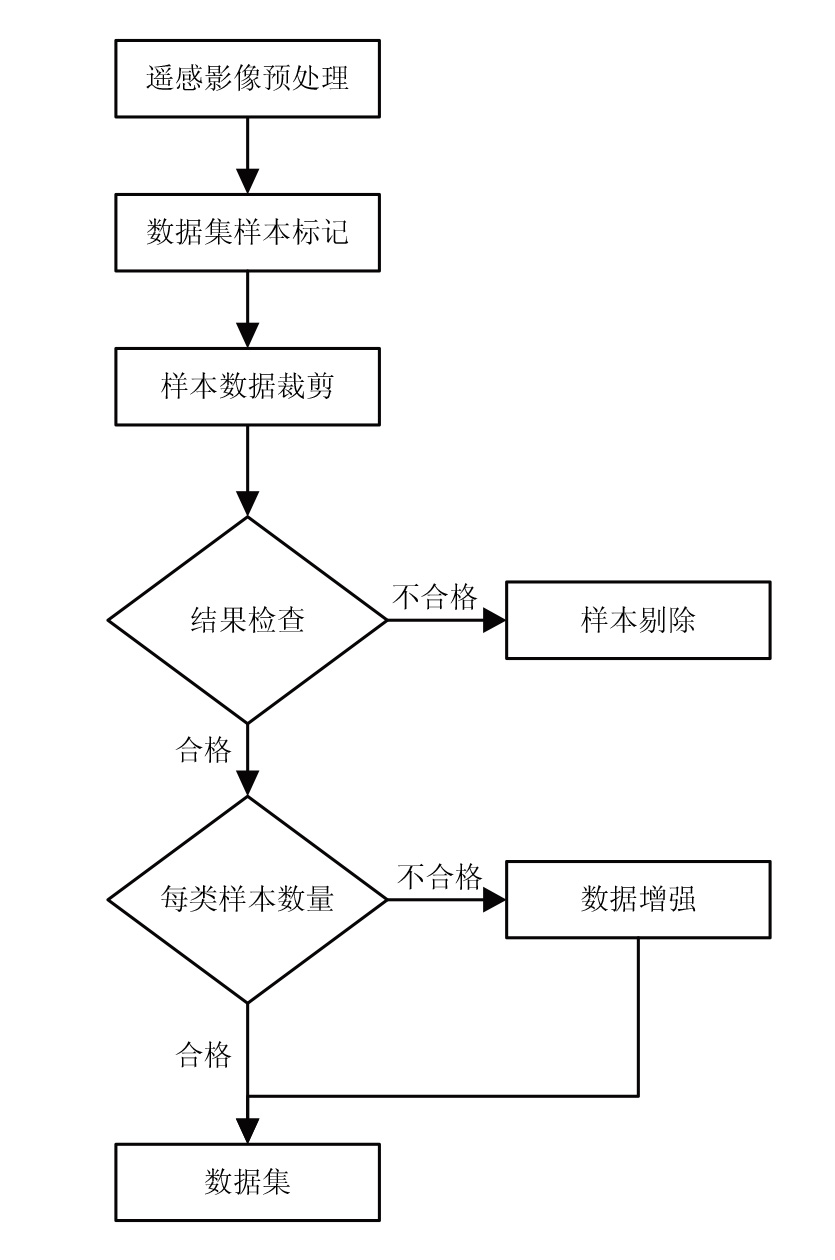
草地资源是畜牧业生产的物质基础和生物多样性的基因库,具有防风固沙、涵养水源的生态功能,草地资源调查及监测意义重大。基于卫星遥感的草地分类不仅能够为草地资源调查提供数据支持,也可为草地物种多样性研究提供依据。基于野外调查数据获取真实样地草地类型信息,利用辐射定标、大气校正、图像融合等预处理后的Landsat8遥感影像,通过目视解译遥感判读的方式,使用ArcGIS软件构建了塔城地区8类草地类型共3360张多光谱遥感图像分类训练数据集。本数据集可为塔城地区草地类型遥感图像分类研究提供数据基础,同时可为其他地区相关领域的科研人员提供数据参考。
数据摘要:
| 项目 | 描述 |
|---|---|
| 数据库(集)名称 | 2023年新疆塔城地区草地类型Landsat8影像训练数据集 |
| 所属学科 | 农业科学 |
| 研究主题 | 草地类型 |
| 数据时间范围 | 2023年 |
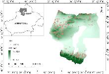
| 数据地理空间覆盖 | 新疆塔城地区,82°16'-87°21′E,43˚25΄-47°15′′N,包括:额敏县、托里县、裕民县、和布克赛尔蒙古自治县、塔城市、沙湾市、乌苏市。 |
| 空间分辨率 | 15 m |
| 数据类型与技术格式 | .tif |
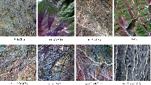
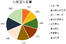
| 数据库(集)组成 | 数据集共包含8个以草地类命名的文件夹,每个文件夹中包含相应草地类型的遥感影像,共3360幅。 |
| 数据量 | 5.74 GB |
| 主要数据指标 | 低地草甸,温性草原化荒漠,温性草甸草原,温性荒漠草原,山地草甸,温性草原,高寒草甸,温性荒漠 |
| 数据可用性 | CSTR:17058.11.sciencedb.agriculture.00135; https://cstr.cn/17058.11.sciencedb.agriculture.00135 DOI:10.57760/sciencedb.agriculture.00135; |
| 经费支持 | 国家自然科学基金项目(32271880,32060321) |