
Journal of Agricultural Big Data ›› 2021, Vol. 3 ›› Issue (4): 20-28.doi: 10.19788/j.issn.2096-6369.210403
Previous Articles Next Articles
Jia He1,2( ), Laigang Wang1,2(), Yan Guo1,2, Yan Zhang1,2, Xiuzhong Yang1,2, Ting Liu1,2, Hongli Zhang1,2
Received:2021-07-08
Online:2021-12-26
Published:2022-01-28
Contact:
Laigang Wang
E-mail:hejia2011@163.com;wlaigang@sina.com
CLC Number:
Jia He, Laigang Wang, Yan Guo, Yan Zhang, Xiuzhong Yang, Ting Liu, Hongli Zhang. Estimating the Leaf Area Index of Maize based on Unmanned Aerial Vehicle Multispectral Remote Sensing[J].Journal of Agricultural Big Data, 2021, 3(4): 20-28.
Table 1
Main parameters of UAV multispectral image acquisition system"
设备 Equipment | 参数 Parameter | 参数值 Value | ||
|---|---|---|---|---|
无人机遥感平台 UAV | 有效载荷 Playload | 0.8 kg | ||
| 航测速度Speed | 2 m/s | |||
| 续航时间Flight time | 20 min | |||
| 传感器 Camera | MicaSense RedEdge-M | |||
| 图像分辨率 Imager resolution | 1280×960 pixels | |||
多光谱传感器 MicaSense RedEdge-M | 光谱波段 Spectral bands | 中心波长 Central wavelength | 波宽 Wavelength width | 灰板反射率 Reference reflectance |
| 蓝 Blue | 475 nm | 20 nm | 51.2 % | |
| 绿 Green | 560 nm | 20 nm | 51.2 % | |
| 红 Red | 668 nm | 10 nm | 51.2 % | |
| 近红外 Near infrared | 840 nm | 40 nm | 51.0 % | |
| 红边 Rededge | 717 nm | 10 nm | 51.1 % | |
Table 2
Vegetation indices in this article"
植被指数 Vegetation index | 计算公式 Formulas | 来源 References |
|---|---|---|
| NDVI (Normalized difference vegetation index) | NDVI =ρnir-ρr/ρnir+ρr | [ |
| OSAVI (Optimize Soil-adjusted vegetation index) | OSAVI =(ρnir-ρr)/( ρnir+ρr+X) | [ |
| EVI (Enhanced Vegetation Index) | EVI=2.5×(ρnir -ρr)/(ρnir +6×ρr -7.5×ρb +1) | [ |
| NDRE(Normalized difference red edge index) | NDRE=(ρnir-ρre)/( ρnir +ρre) | [ |
Table 3
Correlation coefficient between vegetation indices and LAI at different growth stages (n=60)"
参数 Parameter | 植被指数 Vegetation index | ||
|---|---|---|---|
拔节期 Jointing | 抽雄期 Tasseling | 成熟期 Maturation | |
| NDVI | 0.721** | 0.835** | 0.813** |
| OSAVI | 0.816** | 0.817** | 0.827** |
| EVI | 0.713** | 0.831** | 0.794** |
| NDRE | 0.741** | 0.868** | 0.856** |
Table 4
Fitting and performance of monitoring model LAI of maize at different growth stages(n=60)"
生育时期 Growth stages | 植被指数 Vegetation index | 估算模型 | 验证模型 | |||
|---|---|---|---|---|---|---|
估算方程 Equation | 决定系数 Determination coefficient R2 | 标准误差 Standard error SE | 相对误差 Relative error RE | 均方根误差 Root mean square error RMSE | ||
| 拔节期 Jointing | NDVI | Y=2.243x-0.178 | 0.520 | 0.121 | 9.58 | 0.117 |
| OSAVI | Y=1.914x+0.493 | 0.666 | 0.026 | 8.57 | 0.104 | |
| EVI | Y=1.627x+0.395 | 0.508 | 0.133 | 11.31 | 0.147 | |
| NDRE | Y=2.395 x+0.164 | 0.549 | 0.089 | 10.46 | 0.134 | |
| 抽雄期 Tasseling | NDVI | Y=1.523x+1.751 | 0.697 | 0.079 | 10.84 | 0.114 |
| OSAVI | Y=2.174x+0.953 | 0.667 | 0.121 | 9.79 | 0.093 | |
| EVI | Y=2.336x+1.157 | 0.691 | 0.103 | 10.36 | 0.121 | |
| NDRE | Y=5.241x+3.343 | 0.753 | 0.027 | 8.34 | 0.087 | |
| 成熟期Maturation | NDVI | Y=1.954x+0.247 | 0.661 | 0.141 | 13.41 | 0.133 |
| OSAVI | Y=2.517x-0.314 | 0.684 | 0.106 | 10.53 | 0.141 | |
| EVI | Y=1.983x+0.185 | 0.630 | 0.093 | 9.83 | 0.156 | |
| NDRE | Y=5.711x-0.293 | 0.733 | 0.047 | 9.24 | 0.091 | |

Fig.2
Comparison of maize LAI predicted value and measured value (n=60)"
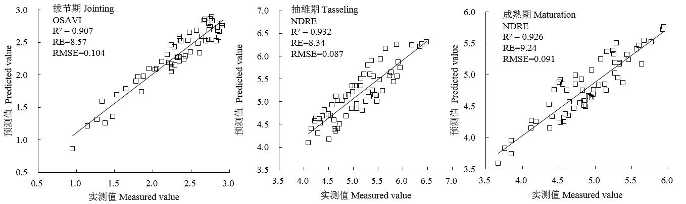
Fig.3
Spatial distribution map of maize LAI at different growth stages"
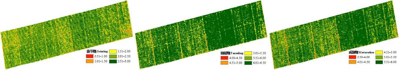
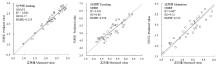
Fig. 4
Relationship between predicted value of LAI mapping and measured value"

| 1 | Jefferies R A, Mackerron D K L. Responses of potato genotypes to drought. II. Leaf area index, growth and yield[J]. Annals of Applied Biology, 1993, 122(1): 105-112. |
| 2 | 李俐,许连香,王鹏新,等.基于叶面积指数的河北中部平原夏玉米单产预测研究[J].农业机械学报,2020,51(06):198-208. |
| Li L, Xu L X, Wang P X, et al. Summer maize yield forecasting based on leaf area index[J]. Transactions of the Chinese Society for Agricultural Machinery, 2018, 49(10):230-239. | |
| 3 | Fu Y, Yang G, Wang J, et al. Winter wheat biomass estimation based on spectral indices, band depth analysis and partial least squares regression using hyperspectral measurements[J]. Computers and Electronics in Agriculture. 2014, 100: 51-59. |
| 4 | Verger A, Vigneau N, Cheron C, et al. Green area index from an unmanned aerial system over wheat and rapeseed crops [J]. Remote Sensing Environment, 2014, 152: 654-664. |
| 5 | Liang L, Di L, Zhang L, et al. Estimation of crop LAI using hyperspectral vegetation indices and a hybrid inversion method [J]. Remote Sensing Environment, 2015, 165: 123-134. |
| 6 | Walthall C, Dulaney W, Anderson M, et al. A comparison of empirical and neural network approaches for estimating corn and soybean leaf area index from Landsat ETM imagery[J]. Remote Sensing of Environment, 2004, 92(4): 465-474. |
| 7 | Propastin P A. Spatial non-stationarity and scale-dependency of prediction accuracy in the remote estimation of LAI over a tropical rainforest in Sulawesi, Indonesia[J]. Remote Sensing of Environment, 2009, 113(10):2234-2242. |
| 8 | Frampton W J, Dash J, Warmouth G, et al. Evaluating the capabilities of Sentinel-2 for quantitative estimation of biophysical variables in vegetation[J]. ISPRS Journal of Photogrammetry and Remote Sensing, 2013, 82: 83-92. |
| 9 | 苏伟, 侯宁, 李琪, 等. 基于Sentinel-2 遥感影像的玉米冠层叶面积指数反演[J]. 农业机械学报, 2018, 49(1): 151-156. |
| Su W, Hou N, Li Q, et al. Retrieving leaf area index of corn canopy based on sentinel-2 remote sensing image[J]. Transaction of the Chinese Society for Agricultural Machinery, 2018, 49(1): 151-156. | |
| 10 | 易秋香. 基于Sentinel-2 多光谱数据的棉花叶面积指数估算[J]. 农业工程学报, 2019, 35(16):189-197. |
| Yi Q X. Remote estimation of cotton LAI using Sentinel-2 multispectral data[J]. Transactions of the Chinese Society of Agricultural Engineering, 2019, 35(16): 189-197. | |
| 11 | 吾木提·艾山江, 买买提·沙吾提, 陈水森, 等. 基于GF-1/2卫星数据的冬小麦叶面积指数反演[J]. 作物学报, 2020, 46(5): 787-797. |
| Umut H, Mamat S, Chen S, et al. Inversion of leaf area index of winter wheat based on GF-1/2 image[J]. Acta Agronomica Sinica, 2020, 46(5): 787-797. | |
| 12 | Alonzo M, Bookhagen B, Mcfadden J P, et al. Mapping urban forest leaf area index with airborne LiDAR using penetration metrics and allometry[J]. Remote Sensing of Environment, 2015, 162(1):141-153. |
| 13 | Zhang L Y, Zhang H H, Niu Y X, et al. Mapping maize water stress based on UAV multispectral remote sensing[J]. Remote Sensing, 2019, 11(6): 605. |
| 14 | Yu N, Li L J, Schmitza N, et al. Development of methods to improve soybean yield estimation and predict plant maturity with an unmanned aerial vehicle based platform[J]. Remote Sensing of Environment, 2016, 187(15): 91-101. |
| 15 | Bhardwaj A, Sam L, Akanksha A, et al. UAVs as Remote Sensing Platform in Glaciology: Present Applications and Future Prospects[J]. Remote Sensing of Environment, 2016, 175(15):196-204. |
| 16 | Niu Y X, Zhang L Y, Zhang H H, et al. Estimating Above-Ground Biomass of Maize Using Features Derived from UAV-Based RGB Imagery[J]. Remote Sensing, 2019, 11(11): 1261. |
| 17 | Guan K, Wu J, Kimball J S, et al. The shared and unique values of optical, fluorescence, thermal and microwave satellite data for estimating large-scale crop yields[J]. Remote Sensing of Environment, 2017, 199: 333-349. |
| 18 | Roosjen P P J, Bbede B, Suomalainen J M, et al. Improved estimation of leaf area index and leaf chlorophyll content of a potato crop using multi-angle spectral data-potential of unmanned aerial vehicle imagery[J]. International Journal of Applied Earth Observation and Geoinformation, 2018, 66: 14-26. |
| 19 | Berni J A J, ZARCO-TEJADA P J, SUAREZ L, et al. Thermal and narrowband multispectral remote sensing for vegetation monitoring from an unmanned aerial vehicle[J]. IEEE Transactions on Geoscience and Remote Sensing, 2009, 47(3): 722-738. |
| 20 | 刘峰, 刘素红, 向阳. 园地植被覆盖度的无人机遥感监测研究[J]. 农业机械学报, 2014, 45(11): 250-257. |
| Liu F, Liu S H, Xiang Y. Study on monitoring fractional vegetation cover of garden plots by unmanned aerial vehicles[J]. Transactions of the Chinese Society for Agriculural Machinery, 2014, 45(11): 250-257. | |
| 21 | Corcoles J I, Ortega J F, Hernandez D, et al. Estimation of leaf area index in onion (Allium cepa L.) using an unmanned aerial vehicle[J]. Biosystems Engineering, 2013, 115(1): 31-42. |
| 22 | Peter P J, Roosjen B B, Juha M, et al. Improved Estimation of Leaf Area Index and Leaf Chlorophyll Content of a Potato Crop using Multi-angle Spectral Data-Potential of Unmanned Aerial Vehicle Imagery[J]. International Journal of Applied Earth Observations and Geoinformation, 2017. |
| 23 | 孙涛, 刘振波, 葛云健, 等. 基于数码相片Gamma 校正的水稻叶面积指数估算[J]. 生态学报, 2014, 34(13):3548-3557. |
| Sun T, Liu Z B, Ge Y J, et al. Estimation of paddy rice leaf area index based on photo gamma correction[J]. Acta Ecologica Sinica, 2014, 34(13): 3548-3557 | |
| 24 | 王瑛. 基于无人机遥感的小麦叶面积指数反演方法研究[D].杨凌: 西北农林科技大学, 2017: 28. |
| Wang Y. Research on the inversion methods of wheat leaf area index based on unmanned aerial vehicle remote sensing[D]. Yangling: Northwest A&F University, 2017: 28. | |
| 25 | 褚洪亮, 肖青, 柏军华, 等. 基于无人机遥感的叶面积指数反演[J]. 遥感技术与应用, 2017, 31(01):140-148. |
| Chu H L, Xiao Q, Bai J H, et al. The retrieval of leaf area index based on remote sensing by unmanned aerial vehicle[J]. Remote Sensing Technology and Application, 2017, 31(1): 140-148. | |
| 26 | 牛庆林, 冯海宽, 杨贵军, 等. 基于无人机数码影像的玉米育种材料株高和LAI监测[J].农业工程学报, 2018, 34(05): 73-82. |
| Niu Q L, Feng H K, Yang G J, et al. Monitoring plant height and leaf area index of maize breeding material based on UAV digital images[J]. Transactions of the Chinese Society of Agricultural Engineering (Transactions of the CSAE), 2018, 34(5): 73-82. | |
| 27 | 孙诗睿, 赵艳玲, 王亚娟, 等. 基于无人机多光谱遥感的冬小麦叶面积指数反演[J].中国农业大学学报, 2019, 24(11):51-58. |
| Sun S R, Zhao Y L, Wang Y J, et al. Leaf area index inversion of winter wheat based on multispectral remote sensing of UAV. Journal of China Agricultural University. 2019, 24(11):51-58. | |
| 28 | 高林, 杨贵军, 李红军, 等. 基于无人机数码影像的冬小麦叶面积指数探测研究[J].中国生态农业学报, 2016, 24(09):1254-1264. |
| Gao L, Yang G J, Li H J, et al. Winter wheat LAI estimation using unmanned aerial vehicle RGB-imaging[J]. Chinese Journal of Eco-Agriculture, 2016, 24(09): 1254-1264. | |
| 29 | 高林, 杨贵军, 王宝山, 等. 基于无人机遥感影像的大豆叶面积指数反演研究[J].中国生态农业学报,2015,23(07):868-876. |
| Gao L, Yang G J, Wang B S, et al. Soybean leaf area index retrieval with UAV (unmanned aerial vehicle) remote sensing imagery[J]. Chinese Journal of Eco-Agriculture, 2015,23(07):868-876. | |
| 30 | 刘良云.叶面积指数遥感尺度效应与尺度纠正[J].遥感学报, 2014, 18(6):1158-1168. |
| Liu L Y. Simulation and correction of spatial scaling effects for leaf area index. Journal of Remote Sensing, 2014, 18(6): 1158 -1168. | |
| 31 | Rouse J W, Haas R H, Schell J A,et al. Monitoring vegetation systems in the Great Plains with ERTS[Z]. NASA Special Publication, 1974, 351: 309-313. |
| 32 | Rondeaux G, Steven M, Bare F. Op-timization of soil-adjusted vegetation indices[J]. Remote Sensing of Environment, 1996, 55: 95-107. |
| 33 | Huete A R. A soil-adjusted vegetation index (SAVI). Remote Sensing of Environment, 1988, 25(3): 295-309. |
| 34 | Barnes E M, Clarke T R, Richards S E, et al. Coincident detection of crop water stress, nitrogen status and canopy density using ground based multispectral data. In: Robert P C. Rust RH LarsonWE, eds., Proceedings of the 5th International Conference on Precision Agriculture, Bloomington. MN. USA. 2000, 7, 16-19. |
| 35 | 陈俊英, 陈硕博, 张智韬, 等. 无人机多光谱遥感反演花蕾期棉花光合参数研究[J].农业机械学报, 2018, 49(10):230-239. |
| Chen J Y, Chen S B, Zhang Z T, et al. Investigation on Photosynthetic Parameters of Cotton during Budding Period by Multi-spectral Remote Sensing of Unmanned Aerial Vehicle [J]. Transactions of the Chinese Society for Agricultural Machinery, 2018, 49(10):230-239. | |
| 36 | 杨海波, 高兴, 黄绍福, 等. 基于卫星波段的马铃薯植株氮素含量估测[J].光谱学与光谱分析, 2019, 39(09):2686-2692. |
| Yang H B, Gao X, Huang S F, et al. Staellite bands based estimation of nitrogen concentration in potato plants[J]. Spectroscopy and Spectral Analysis, 2019, 39(09):2686-2692. |
| [1] | ZHANG Zhaoxu, XIAO Yue, GOU Wentao, CUI Jin. Study on Drought Monitoring and Spatiotemporal Change in Henan Province Based on Sun/solar-induced Chlorophyll Fluorescence Remote Sensing [J]. Journal of Agricultural Big Data, 2023, 5(1): 76-86. |
| [2] | ZHANG Zhaoxu, CUI Jin, GOU Wentao, XIAO Yue. Drought Monitoring and Spatiotemporal Changes Analysis in North China Plain Based on Temperature Vegetation Dryness Index [J]. Journal of Agricultural Big Data, 2023, 5(1): 95-107. |
| [3] | Xinglong Liu, Yu Wang, Xiaoxi Wang, Keqin Wang. A Dataset of Coccinellidae in Farmlands in Harbin, Heilongjiang Province from 2018 to 2021 [J]. Journal of Agricultural Big Data, 2022, 4(4): 39-44. |
| [4] | Ayitula Maimaitizunong, Shuai Yanju, Haodong Wei, Zhen He, Qinxi Xiao, Qiong Hu, Baodong Xu, Liangzhi You, Cougui Cao, Lin Ling. Evaluation of Green Development of Rice-Based Cropping Systems Using Remote Sensing Data and the DNDC Model: Case Study of Qianjiang City [J]. Journal of Agricultural Big Data, 2021, 3(3): 33-44. |
| [5] | Qiang Li, Maofang Gao, Ying Fang. Research on the Construction of the Agricultural Big Data Information Platform [J]. Journal of Agricultural Big Data, 2021, 3(2): 24-30. |
| [6] | Mingxu Zhang, Yuan Chen, Tuya Xilin, Ru Zhang, Yaqiong Bi, Chunhong Zhang, Taotao Wu, Minhui Li. Application and Prospects for Big Data of Traditional Chinese Medicine Resources [J]. Journal of Agricultural Big Data, 2021, 3(1): 14-24. |
| [7] | Kai Li, Qinghua Huang, Ruqing Zhong, Liang Chen, Weifeng Yuan, Hongfu Zhang. Analysis of the Contents and Correlations of Nutrient Components in Different Maize Cultivars [J]. Journal of Agricultural Big Data, 2020, 2(4): 70-77. |
| [8] | Yao Xie, Yan Tang, Xia Liu, Jing Meng, Lei Wang. Bibliometrics-based Analysis of Advances in Maize Adversity Stress Mechanism [J]. Journal of Agricultural Big Data, 2020, 2(2): 112-124. |
| [9] | Laigang Guo Yan Wang Lijun He Jia Yang Xiuzhong Zhang Hongli Zheng Guoqing Wang. Developing a Combined Map of the Spatial Distribution of Autumn Crops in Henan Province Using Multi-source Remote Sensing [J]. Journal of Agricultural Big Data, 2020, 2(1): 53-59. |
| [10] | Xiaoman Li,Yang Zhang,Qian Xu,Nengfu Xie. Bibliometrics-Based Analysis of Advances in Plant Phenomics Research [J]. Journal of Agricultural Big Data, 2019, 1(2): 64-75. |
| [11] | Li Xianjiang, Chen Youqi, Zou Jinqiu, Shi Shuqin, Guo Tao, Cai Weimin, Chen Hao. Application of Convolutional Neural Networks in High-Resolution Image Classification [J]. Journal of Agricultural Big Data, 2019, 1(1): 67-77. |
|
||

