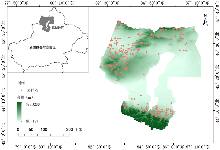
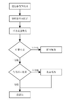
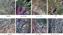
Landsat8 Image Training Data Set of Grassland Types in Tarbagatay Prefecture in 2023
YANG YanXiao1(), LI QuanSheng1, HU Lin2,3, ZHANG XianHua4(), SUN Wei2,3,*()
1. College of Computer and Information Engineering, Xinjiang Agricultural University, Urumqi 830052, China 2. Agricultural Information Institute of CAAS, Beijing 100081, China 3. National Agriculture Science Data Center, Beijing 100081, China 4. College of Grassland Science, Xinjiang Agricultural University, Urumqi 830052, China
YANG YanXiao, LI QuanSheng, HU Lin, ZHANG XianHua, SUN Wei. Landsat8 Image Training Data Set of Grassland Types in Tarbagatay Prefecture in 2023[J].Journal of Agricultural Big Data, 2025, 7(2): 255-260.

 ), LI QuanSheng1, HU Lin2,3, ZHANG XianHua4(