农业大数据学报 ›› 2025, Vol. 7 ›› Issue (1): 126-131.doi: 10.19788/j.issn.2096-6369.100045

• 数据资源 • 上一篇    下一篇

2024年北京小麦全生长周期多光谱图像数据集

王建丽1(), 曲明山2, 刘震宇1, 史凯丽1, 张石锐1, 李光伟1, 张钟莉莉1,*()   

  1. 1.北京市农林科学院智能装备技术研究中心,北京 100097
    2.北京市农业技术推广站,北京 100029
  • 收稿日期:2024-09-24 接受日期:2024-11-07 出版日期:2025-03-26 发布日期:2025-02-05
  • 通讯作者: 张钟莉莉,E-mail:lilizhangzhong@163.com
  • 作者简介:王建丽,E-mail:18434766397@163.com
  • 基金资助:
    国家重点研发计划项目(2022YFD1900404);北京市农林科学院优秀青年科学基金(YXQN202304)

Multispectral Image Dataset of Wheat Full Growth Cycle in Beijing Province in 2024

WANG JianLi1(), QU MingShan2, LIU ZhenYu1, SHI KaiLi1, ZHANG ShiRui1, LI GuangWei1, ZHANG ZhongLili1,*()   

  1. 1. Intelligent Equipment Technology Research Center of Beijing Academy of Agriculture and Forestry Sciences, Beijing 100097, China
    2. Beijing Agricultural Technology Extension Station, Beijing 100029, China
  • Received:2024-09-24 Accepted:2024-11-07 Published:2025-03-26 Online:2025-02-05

摘要:

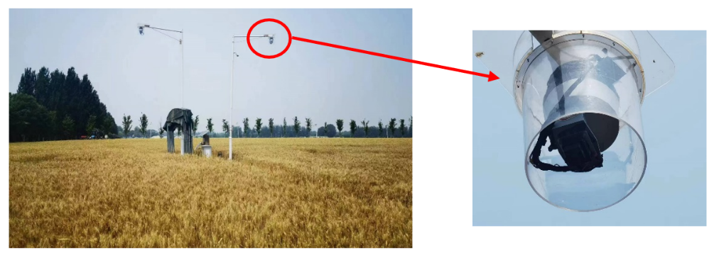
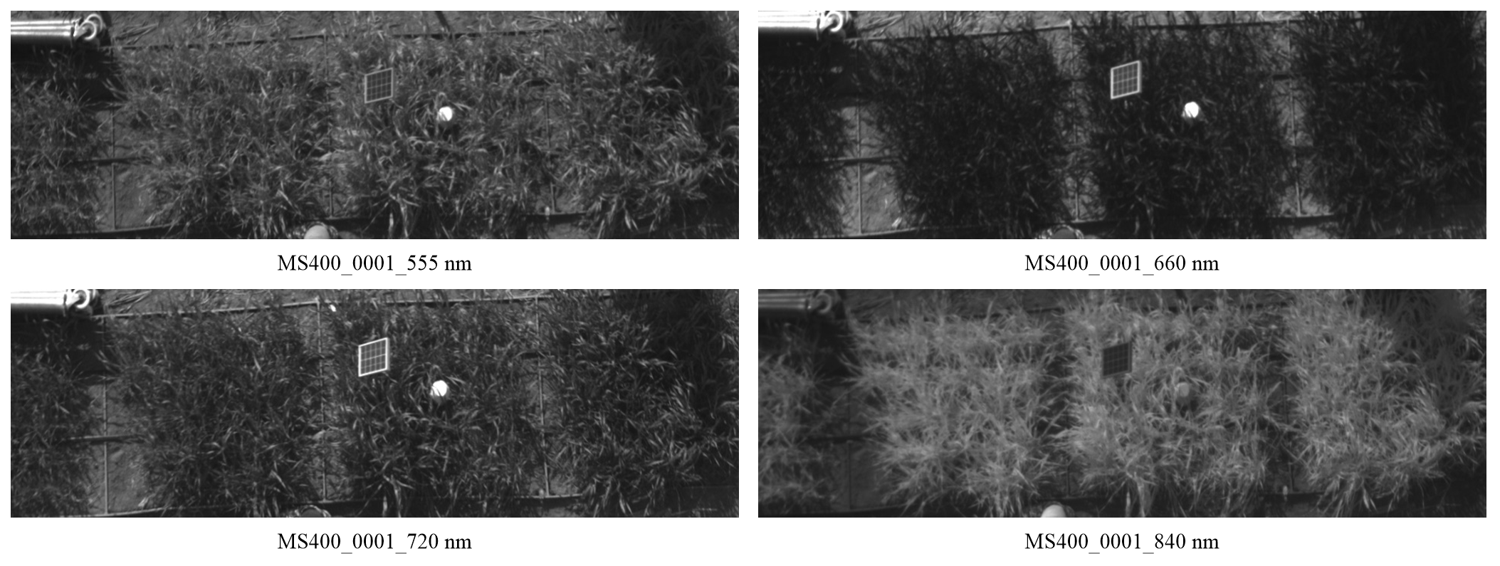
小麦是全球主要粮食作物之一,随着物联网技术的发展,多光谱动态采集技术通过捕捉丰富的光谱信息,识别可见光范围内难以区分的物质和特征,从而为水肥亏缺诊断、病虫害预警等提供更详细的数据支撑。目前大部分研究采用无人机遥感平台搭载多光谱相机获取小麦冠层多光谱图像,然而无人机运行维护成本较高,且无法实时采集小麦整个生长周期内的连续生长信息,相比而言,多光谱原位监测设备能够逐日实时采集特定区域内作物整个生长周期的生长数据,从而实现连续性的作物生长动态监测。本研究在2024年4月9日至6月6日期间,对北京市小汤山国家精准农业研究示范基地内设置的试验田小麦的拔节期、孕穗期、开花期和灌浆期图像进行了采集。经筛选和整理后形成的有效数据为每日6点-18点采集的多光谱图像,采集频率为一小时,数据量为1.42 GB。图像数据由布设在自然大田环境中的多光谱原位监测设备定时拍摄而得,并以文件夹形式存储。图像经过专业人员筛选和整理,确保数据高质量和可靠性。本数据集可通过多光谱图像数据实现对小麦的水肥亏缺诊断、病虫害监测等任务,将提取出的反射率值、植被指数、颜色特征、纹理特征、植被覆盖度等信息带入预测模型中进行分析预测,同时本数据集还适用于构建小麦叶绿素含量、生物量估算的网络模型等研究。

数据摘要:

项目 描述
数据库(集)名称 2024年北京小麦全生长周期图像数据集
所属学科 农业科学
研究主题 计算机视觉
数据时间范围 2024 年 4月—2024 年6 月
时间分辨率 1小时
数据地理空间覆盖 北京市小汤山国家精准农业研究示范基地试验田
数据类型与技术格式 .tif
数据库(集)组成 数据集为小麦冠层多光谱图像数据,包含 610个时间段的数据。
数据量 1.42 GB
主要数据指标 多光谱图像
数据可用性 https://cstr.cn/17058.11.sciencedb.agriculture.00121
https://doi.org/10.57760/sciencedb.agriculture.00121
经费支持 国家重点研发计划项目(2022YFD1900404),北京市农林科学院优秀青年科学基金(YXQN202304)

关键词: 原位实时监测, 多光谱图像, 北京, 小麦

Abstract:

Wheat is one of the major global food crops, and with the development of Internet of Things (IoT) technology, multispectral dynamic acquisition technology identifies substances and features that are difficult to distinguish in the visible range by capturing rich spectral information, thus providing more detailed data support for water and fertilizer deficiency diagnosis, pest and disease warning, etc. Currently, most studies use a drone remote sensing platform equipped with a multispectral camera to acquire multispectral images of the wheat canopy, however, the drone has high operation and maintenance costs and is unable to collect continuous growth information throughout the entire growth cycle of wheat in real time, in contrast to multispectral in-situ monitoring equipment that can collect real-time growth data throughout the entire growth cycle of a crop in a specific region on a day-by-day basis, thus realizing continuous crop growth dynamics monitoring. In this study, between April 9 and June 6, 2024, images of wheat in the test field set up in the National Precision Agriculture Research and Demonstration Base in Xiaotangshan, Beijing, were collected at the nodulation, earning, flowering, and grouting stages. The valid data after screening and organizing were multispectral images collected from 6:00 to 18:00 every day at a frequency of one hour, with a data volume of 1.42 GB. The image data were captured by the multispectral in situ monitoring equipment deployed in the natural field environment at regular intervals, and stored in the form of folders. The data are screened and organized by professional staff to ensure high quality and reliability. This dataset can be used to realize the tasks of water and fertilizer deficit diagnosis, pest and disease monitoring of wheat through the multispectral image data. The extracted information such as reflectance value, vegetation index, color characteristics, texture characteristics, vegetation coverage and other information can be brought into the prediction model for analysis and prediction. At the same time, the present dataset is also suitable for constructing the chlorophyll content of wheat, network model for biomass estimation and other studies.

Data summary:

Items Description
Dataset name Multispectral image Dataset of Wheat Full Growth Cycle in Beijing Province in 2024
Specific subject area Agricultural science
Research topic Computer vision
Time range April 2024-June 2024
Temporal resolution 1 hour
Geographical scope National Precision Agriculture Research and Demonstration Base in Xiaotangshan, Beijing,
Data types and technical formats .tif
Dataset structure The dataset consists of multispectral images of wheat canopy, covering 610 time periods.
Volume of dataset 1.42 GB
Key index in dataset Multispectral images
Data accessibility https://cstr.cn/17058.11.sciencedb.agriculture.00121
https://doi.org/10.57760/sciencedb.agriculture.00121
NASDC Access Link: https://agri.scidb.cn/, Restricted Access
Financial support National Key Research and Development Program of China (2022YFD1900404), Beijing Academy of Agricultural and Forestry Excellent Youth Science Fund (YXQN202304)

Key words: In situ real-time monitoring, multispectral imagery, Beijing, wheat