
Journal of Agricultural Big Data ›› 2023, Vol. 5 ›› Issue (2): 2-8.doi: 10.19788/j.issn.2096-6369.230202
Previous Articles Next Articles
SHEN Ge1( ), LIU Hang2, LI DanDan3, CHEN Shi4, ZOU JinQiu3,*()
Received:2023-06-06
Online:2023-06-26
Published:2023-08-15
Contact:
ZOU JinQiu
SHEN Ge, LIU Hang, LI DanDan, CHEN Shi, ZOU JinQiu. A 10 m Spatial Resolution Dataset for the Spatial Distribution of Cropland Resources in the Three Northeastern Provinces from 2020 to 2022[J].Journal of Agricultural Big Data, 2023, 5(2): 2-8.
Table 1
Introduction of the Sentinel-2 satellite band"
| 波段 | 中央波长 (μm) | 空间分辨率 (m) |
|---|---|---|
| 波段1 -沿海气溶胶 | 0.443 | 60 |
| 波段2 - 蓝 | 0.49 | 10 |
| 波段3 - 绿 | 0.56 | 10 |
| 波段4 - 红 | 0.665 | 10 |
| 波段5 - 植被红边 | 0.705 | 20 |
| 波段6 -植被红边 | 0.74 | 20 |
| 波段7 -植被红边 | 0.783 | 20 |
| 波段8 - 近红外 | 0.842 | 10 |
| 波段8A -植被红边 | 0.865 | 20 |
| 波段9 - 水蒸气 | 0.945 | 60 |
| 波段10 - 短波红外线-卷云 | 1.375 | 60 |
| 波段11 -短波红外线 | 1.61 | 20 |
| 波段12 -短波红外线 | 2.19 | 20 |
Table 2
The number of images counted by region"
| 时段 | 黑龙江省 | 辽宁省 | 吉林省 | ||||||
|---|---|---|---|---|---|---|---|---|---|
| 2020 | 2021 | 2022 | 2020 | 2021 | 2022 | 2020 | 2021 | 2022 | |
| 1月 | 1119 | 1109 | 1119 | 419 | 399 | 419 | 473 | 479 | 473 |
| 2月 | 1048 | 1030 | 1054 | 379 | 385 | 393 | 456 | 467 | 469 |
| 3月 | 1151 | 1152 | 1173 | 420 | 427 | 424 | 506 | 498 | 502 |
| 4月 | 1137 | 1129 | 1156 | 410 | 412 | 414 | 477 | 473 | 473 |
| 5月 | 1145 | 1156 | 1190 | 424 | 422 | 425 | 496 | 498 | 500 |
| 6月 | 1124 | 1093 | 1153 | 405 | 401 | 398 | 497 | 480 | 486 |
| 7月 | 1137 | 1157 | 1194 | 410 | 422 | 421 | 476 | 498 | 498 |
| 8月 | 1141 | 1160 | 1188 | 425 | 424 | 421 | 504 | 498 | 503 |
| 9月 | 1134 | 1105 | 1149 | 403 | 386 | 397 | 484 | 474 | 482 |
| 10月 | 1138 | 1151 | 1205 | 419 | 424 | 431 | 498 | 497 | 511 |
| 11月 | 1072 | 1099 | 1103 | 392 | 412 | 425 | 481 | 487 | 503 |
| 12月 | 1156 | 1122 | 0 | 441 | 424 | 0 | 503 | 488 | 0 |
| 小计 | 13502 | 13463 | 12684 | 4947 | 4938 | 4568 | 5851 | 5837 | 5400 |
| 总计 | 71190 | ||||||||
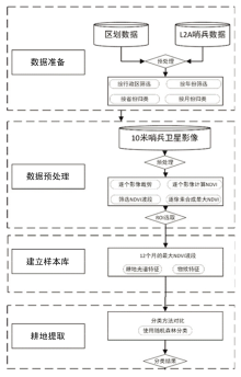
Fig. 1
Flow chart of cultivated land extraction process"

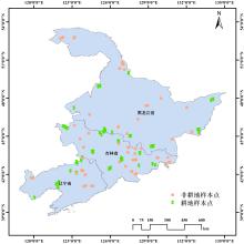
Fig. 2
Distribution of sample points"

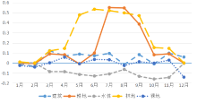
Fig. 3
Time series NDVI curve of sample points"

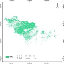
Fig. 4
Spatial distribution of cultivated land in Jilin Province in 2020"

Table 3
Accuracy verification results (%)"
| 地区 | 2020 | 2021 | 2022 |
|---|---|---|---|
| 黑龙江省 | 95.24 | 93.88 | 89.80 |
| 辽宁省 | 97.81 | 97.08 | 91.24 |
| 吉林省 | 96.27 | 95.65 | 93.16 |
| [1] |
Wu M Q, Huang W J, Niu Z, et al. Validation of synthetic daily Landsat NDVI time series data generated by the improved spatial and temporal data fusion approach[J]. Information Fusion, 2018, 40: 34-44.
doi: 10.1016/j.inffus.2017.06.005 |
| [2] |
Denize J, Hubert-Moy L, Betbeder J, et al. Evaluation of using sentinel-1 and -2 time-series to identify winter land use in agricultural landscapes[J], . Remote Sensing, 2019, 11(2): 37.
doi: 10.3390/rs11010037 |
| [3] | 何蔓, 张军岩. 全球土地利用与覆盖变化(LUCC)研究及其进展[J], . 国土资源, 2005(9): 22-25. |
| He M, Zhang J Y. Scientific research progress of global land-use and land-cover changes project[J]. Land and Resources, 2005(9): 22-25. (in Chinese) | |
| [4] |
White E V, Roy D P. A contemporary decennial examination of changing agricultural field sizes using Landsat time series data[J]. Geo: Geography and Environment, 2015, 2(1): 33-54.
doi: 10.1002/geo2.4 |
| [5] |
蔡志文, 何真, 王文静, 等. 基于多源国产高分卫星时空信息的米级分辨率耕地提取[J]. 遥感学报, 2022, 26(7): 1368-1382.
doi: 10.11834/jrs.20221069 |
|
Cai Z W, He Z, Wang W J, et al. Mapping cropland at metric resolution using the spatiotemporal information from multi-source GF satellite data[J]. National Remote Sensing Bulletin, 2022, 26(7): 1368-1382. (in Chinese)
doi: 10.11834/jrs.20221069 |
|
| [6] |
Fritz S, See L, Kummer S. Mapping global cropland and field size[J]. Global Change Biology, 2015, 21(5): 1980-1992.
doi: 10.1111/gcb.12838 pmid: 25640302 |
| [7] |
Graesser J, Ramankutty N. Detection of cropland field parcels from Landsat imagery[J], . Remote Sensing of Environment 2017, 201: 165-180.
doi: 10.1016/j.rse.2017.08.027 |
| [8] |
Xiong J, Thenkabail P S, Gumma K M, et al. Automated cropland mapping of continental Africa using Google Earth Engine cloud computing[J]. ISPRS Journal of Photogrammetry and Remote Sensing, 2017, 126: 225-244.
doi: 10.1016/j.isprsjprs.2017.01.019 |
| [9] |
Xu L, Ming D P, Zhou W, et al. Farmland extraction from high spatial resolution remote sensing images based on stratified scale pre-estimation[J]. Remote Sensing, 2019, 11(2): 108.
doi: 10.3390/rs11020108 |
| [10] |
Zhang D J, Pan Y Z, Zhang J S, et al. A generalized approach based on convolutional neural net-works for large area cropland mapping at very high resolution[J]. Remote Sensing of Environment, 2020, 247: 111912.
doi: 10.1016/j.rse.2020.111912 |
| [11] | Yang J W, Zhang J S, Zhu S, et al. Cropland mapping in fragmented agricultural landscape using modified pyramid scene parsing network[J]. IGARSS 2019-2019 IEEE International Geoscience and Remote Sensing Symposium. Yokohama, Japan: IEEE, 2019: 9831-9834. |
| [12] | 宋德娟, 张承明, 杨晓霞, 等. 高分二号遥感影像提取冬小麦空间分布[J]. 遥感学报, 2020, 24(5): 596-608. |
| Song D J, Zhang C M, Yang X X, et al. Extracting winter wheat spatial distribution information from GF-2 image[J]. Journal of Remote Sensing, 2020, 24(5): 596-608. (in Chinese) | |
| [13] | 徐俊峰, 张保明. 多特征融合的高分辨率遥感影像飞机目标变化检测[J]. 遥感学报, 2020, 24(1): 37-52. |
| Xu J F, Zhang B M. Aircraft target change detection for high-resolution remote sensing images using multi-feature fusion[J]. Journal of Remote Sensing, 2020, 24(1): 37-52. (in Chinese) |
| [1] | LIU Meng, WANG JuanLe, LI Kai, JIANG JiaWei, ZOU WeiHao. Fine Classification Dataset of Crops in the Transboundary Basin of the Heilongjiang River Between Russia and China, 2015-2023 [J]. Journal of Agricultural Big Data, 2025, 7(1): 22-30. |
| [2] | ZOU WeiHao, WANG JuanLe, YANG KeMing, LIU Meng, JIANG JiaWei, LIU YaPing. Spatio-temporal Changes of Land Cover and Cultivated Land Resources in the Cross-border Amur River Basin Between China and Russia from 1990 to 2020 [J]. Journal of Agricultural Big Data, 2025, 7(1): 2-13. |
| [3] | LU JunYan. Research Progress on Remote Sensing Image Invisible Watermarking Technology in Data Flow Scenarios [J]. Journal of Agricultural Big Data, 2024, 6(2): 220-229. |
| [4] | CAI HuiNa, WANG Ruei-Yuan. A Dataset on Spatial Distribution of Mangroves in Qi'ao Island, Zhuhai, Guangdong Province from 2000 to 2020 [J]. Journal of Agricultural Big Data, 2023, 5(2): 9-15. |
| [5] | ZHANG Zhaoxu, CUI Jin, GOU Wentao, XIAO Yue. Drought Monitoring and Spatiotemporal Changes Analysis in North China Plain Based on Temperature Vegetation Dryness Index [J]. Journal of Agricultural Big Data, 2023, 5(1): 95-107. |
| [6] | ZHANG Zhaoxu, XIAO Yue, GOU Wentao, CUI Jin. Study on Drought Monitoring and Spatiotemporal Change in Henan Province Based on Sun/solar-induced Chlorophyll Fluorescence Remote Sensing [J]. Journal of Agricultural Big Data, 2023, 5(1): 76-86. |
| [7] | Jia He, Laigang Wang, Yan Guo, Yan Zhang, Xiuzhong Yang, Ting Liu, Hongli Zhang. Estimating the Leaf Area Index of Maize based on Unmanned Aerial Vehicle Multispectral Remote Sensing [J]. Journal of Agricultural Big Data, 2021, 3(4): 20-28. |
| [8] | Ayitula Maimaitizunong, Shuai Yanju, Haodong Wei, Zhen He, Qinxi Xiao, Qiong Hu, Baodong Xu, Liangzhi You, Cougui Cao, Lin Ling. Evaluation of Green Development of Rice-Based Cropping Systems Using Remote Sensing Data and the DNDC Model: Case Study of Qianjiang City [J]. Journal of Agricultural Big Data, 2021, 3(3): 33-44. |
| [9] | Qiang Li, Maofang Gao, Ying Fang. Research on the Construction of the Agricultural Big Data Information Platform [J]. Journal of Agricultural Big Data, 2021, 3(2): 24-30. |
| [10] | Mingxu Zhang, Yuan Chen, Tuya Xilin, Ru Zhang, Yaqiong Bi, Chunhong Zhang, Taotao Wu, Minhui Li. Application and Prospects for Big Data of Traditional Chinese Medicine Resources [J]. Journal of Agricultural Big Data, 2021, 3(1): 14-24. |
| [11] | Laigang Guo Yan Wang Lijun He Jia Yang Xiuzhong Zhang Hongli Zheng Guoqing Wang. Developing a Combined Map of the Spatial Distribution of Autumn Crops in Henan Province Using Multi-source Remote Sensing [J]. Journal of Agricultural Big Data, 2020, 2(1): 53-59. |
| [12] | Xiaoman Li,Yang Zhang,Qian Xu,Nengfu Xie. Bibliometrics-Based Analysis of Advances in Plant Phenomics Research [J]. Journal of Agricultural Big Data, 2019, 1(2): 64-75. |
| [13] | Li Xianjiang, Chen Youqi, Zou Jinqiu, Shi Shuqin, Guo Tao, Cai Weimin, Chen Hao. Application of Convolutional Neural Networks in High-Resolution Image Classification [J]. Journal of Agricultural Big Data, 2019, 1(1): 67-77. |

