| [1] |
王辰怡, 高秉博, Chinzorig S, 等. 2022年克鲁伦河流域土壤全氮含量与土壤全磷含量数据集. 农业大数据学报, 2023, 5(3): 104-111.
doi: 10.19788/j.issn.2096-6369.230314
|
| [2] |
FANG H. Effect of soil conservation measures and slope on runoff, soil, TN, and TP losses from cultivated lands in northern China. Ecological Indicators, 2021, 126: 107677. DOI: 10.1016/j.ecolind.2021.107677.
|
| [3] |
SHEN W, ZHANG L, LI S, et al. A framework for evaluating county-level non-point source pollution: joint use of monitoring and model assessment. Science of the Total Environment, 2020, 722: 137956. DOI:10.1016/j.scitotenv.2020.137956.
|
| [4] |
PENG K, LI J, ZHOU X, et al. Simulation and control of non-point source pollution based on MIKE model: A case study of Danjiang river basin, China. Ecohydrology & Hydrobiology, 2023, 23(4): 554-568. DOI:10.1016/j.ecohyd.2023.08.001.
|
| [5] |
冯爱萍, 吴传庆, 王雪蕾, 等. 海河流域氮磷面源污染空间特征遥感解析. 中国环境科学, 2019, 39(7): 2999-3008.
|
| [6] |
ADU J T, KUMARASAMY M V. Assessing non-point source pollution models: a review. Polish Journal of Environmental Studies, 2018, 27(5). DOI: 10.15244/pjoes/76497.
|
| [7] |
丁建华, 沈旭, 常文婷, 等. 基于SWAT模型的南苕溪流域面源污染时空格局研究. 环境污染与防治, 2023, 45(12): 1654-1659.
|
| [8] |
LIU J, ZHANG L, ZHANG Y, et al. Validation of an agricultural non-point source (AGNPS) pollution model for a catchment in the Jiulong River watershed, China. Journal of Environmental Sciences, 2008, 20(5): 599-606. DOI:10.1016/S1001-0742(08)62100-2.
pmid: 18575114
|
| [9] |
赵串串, 冯倩, 侯文涛, 等. 基于AnnAGNPS模型的灞河流域非点源污染模拟研究. 环境污染与防治, 2019, 41(3):317-322.
|
| [10] |
尹京晨, 丁晗, 李泽利, 等. 基于SPARROW模型的面源污染模拟研究进展. 环境工程, 2022, 40(6):253-260+294.
|
| [11] |
XUE J, WANG Q, ZHANG M. A review of non-point source water pollution modeling for the urban-rural transitional areas of China: Research status and prospect. Science of the Total Environment, 2022, 826: 154146. DOI:10.1016/j.scitotenv.2022.154146.
|
| [12] |
张秀红, 李任革, 赵月帅, 等. 基于DPeRS模型的西安市农业空间面源污染特征解析. 环境工程, 2023, 41(12):142-149.
|
| [13] |
成立新, 岳林芳, 郑重, 等. 内蒙古自治区畜禽养殖粪污的调研情况. 当代畜禽养殖业, 2019, (6):59-64.
|
| [14] |
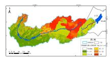
冯爱萍, 黄莉, 王雪蕾, 等. 浦阳江流域(浦江县段)面源污染模型估算及河流生态缓冲带重点区域识别. 环境工程学报, 2022, 16(1): 73-84.
|

 ), WANG ChenYi2, HUANG Li1, GAO BingBo2, YIN WenJie1, SUKHBAATAR Chinzorig3, WANG QingTao1, CHEN HuaJie1, FENG QuanLong2, LI ShuHua4, FENG AiPing1,*(