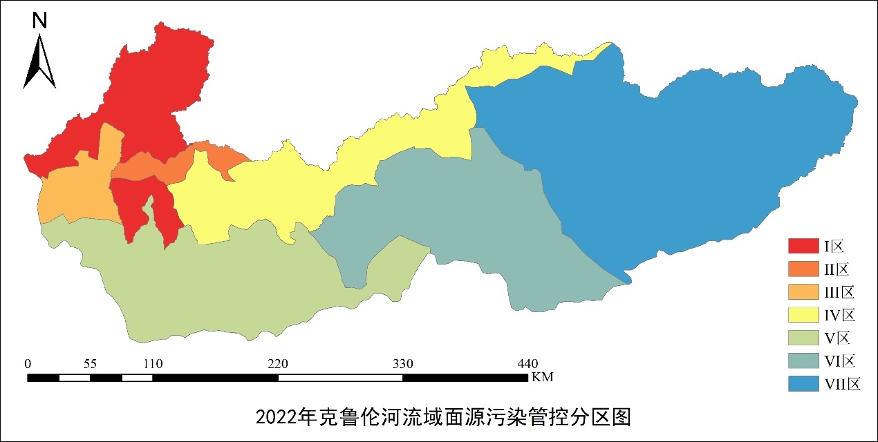
Journal of Agricultural Big Data ›› 2025, Vol. 7 ›› Issue (1): 43-50.doi: 10.19788/j.issn.2096-6369.100034

Previous Articles     Next Articles

Dataset on Grassland Non-Point Source Pollution Management and Control Zones for the Kherlen River Basin in 2022

LI ShuHua1(), LI XiaoLan1, LIU Yu1,*(), GAO BingBo2, Sukhbaatar Chinzorig3, FENG AiPing4, LI CunJun1, REN YanMin1   

  1. 1. Information Technology Research Center, Beijing Academy of Agriculture and Forestry Sciences, Beijing 100097, China
    2. College of Land Science and Technology, China Agricultural University, Beijing 100083, China
    3. Institute of Geography and Geoecology, Mongolian Academy of Sciences, Ulaanbaatar 15170, Mongolia
    4. Ministry of Ecology and Environment Center for Satellite Application on Ecology and Environment, Beijing 100094, China
  • Received:2024-05-14 Accepted:2024-08-13 Online:2025-03-26 Published:2025-02-05
  • Contact: LIU Yu

Abstract:

The ecological and environmental safety of the Kherlen River Basin is directly related to the sustainable development of both China and Mongolia. Scientific delineation of non-point source pollution control units is crucial for precise implementation of water environment policies and efficient management in the basin. However, currently, there is a lack of effective zoning data to guide specific measures in pollution control in this region. Traditional methods of dividing pollution control units struggle to accurately reflect the differences in grassland non-point source pollution, thereby affecting management effectiveness to some extent. Grassland non-point source pollution is influenced by multiple factors, exhibiting both attribute repetition and spatial continuity. To capture these characteristics more accurately, a clustering method that balances attribute repetition and spatial continuity is required. In this study, focusing on the Kherlen River Basin and targeting the influencing factors of grassland non-point source pollution, we comprehensively considered key continuous data such as annual average precipitation, temperature, digital elevation, grassland carrying capacity, and soil total nitrogen and phosphorus content. Utilizing the Spatial Toeplitz Inverse Covariance Clustering (STICC) method, which effectively handles attribute dependencies and spatial consistency strategies, we conducted clustering analysis and constructed a 2022 dataset for non-point source pollution control zoning in the Kherlen River Basin. To validate the accuracy of this dataset, we compared the zoning effects using the DUNN clustering accuracy evaluation index with other traditional zoning results. The results showed that the STICC method outperforms methods like K-Means, Spectral K-Means, GMM, and Repeated Bisection in clustering accuracy. It can more effectively identify heterogeneous pollution areas, significantly enhancing the precision of management. Additionally, this study preserved the original continuity of the data, resulting in a more accurate depiction of pollution characteristics. Compared to traditional methods, the zoning data provided in this study improves detail presentation by more than 50%. This dataset not only offers strong support for in-depth studies on non-point source pollution characteristics in the Kherlen River Basin but also provides a solid data foundation for related control decisions.

Data summary:

Item Description
Dataset name Dataset on Grassland Non-Point Source Pollution Management and Control Zones for the Kherlen River Basin in 2022
Specific subject area Land resources and information technology
Research topic Non-Point Source Pollution Management and Control Zones
Time range 2022
Geographical scope Kherlen River Basin
Spatial resolution 1 km
Data types and technical formats .shp
Dataset structure The dataset includes a special map and basic dataset for the control zones of non-point source pollution in the Kherlen River basin in 2022. The special map consists of two maps of primary and secondary control zones, and the basic dataset consists of six key indicator data files for zoning.
Volume of dataset 163.8 MB
Key index in dataset Primary control zone for non-point source pollution, secondary control zone for non-point source pollution
Data accessibility https://doi.org/10.57760/sciencedb.08471
https://cstr.cn/31253.11.sciencedb.08471
Financial support Research on Monitoring and Assessment Technology of Non-point Pollution of Kherlen River Based on Remote Sensing(2021YFE0102300)

Key words: Kherlen River basin, non-point source pollution, STICC, management and control zones, spatial clustering