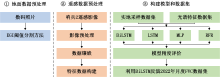
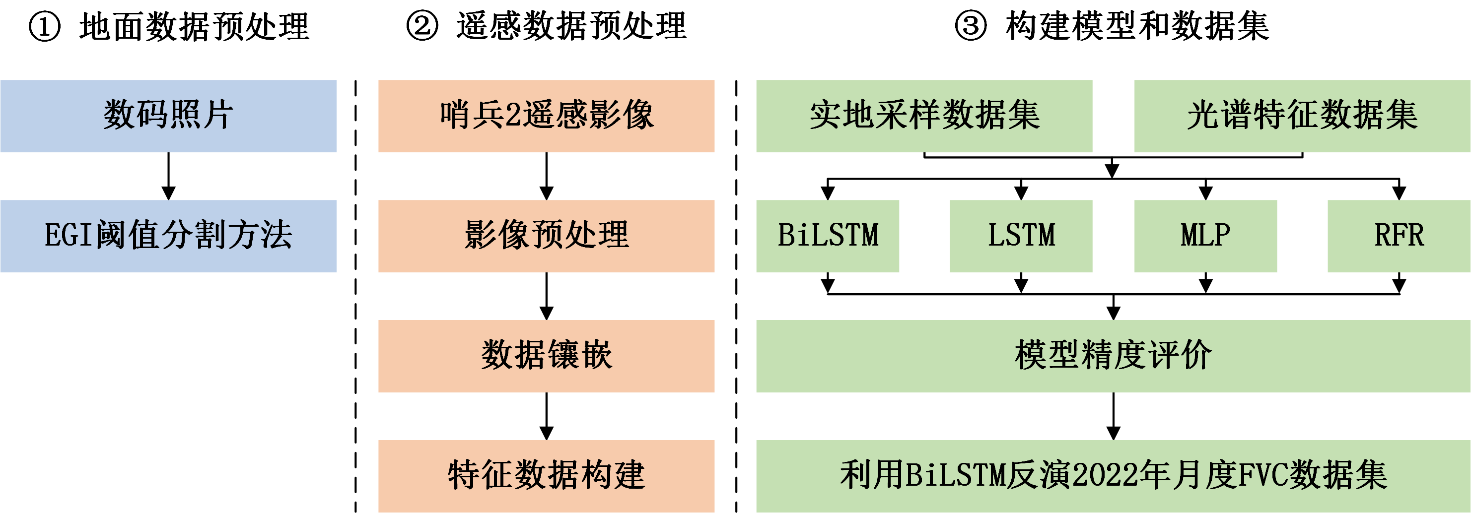
| [1] |
赵文慧, 陈妮, 闫瑞, 等. 近20年来北洛河流域植被覆盖度随地形因子变化特征探究. 水土保持研究, 2016, 23(4): 10-14.
|
| [2] |
陈妮, 李谭宝, 张晓萍, 等. 北洛河流域植被覆盖度时空变化的遥感动态分析. 水土保持通报, 2013, 33(3): 206-210.
|
| [3] |
程佳蕊, 毛德华, 玉山, 等. 1980—2020年克鲁伦河流域草地的时空变化. 水土保持通报, 2022, 42(3):296-303.
|
| [4] |
冯权泷, 陈泊安, 李国庆, 等. 遥感影像样本数据集研究综述. 遥感学报, 2022, 26(4): 589-605.
|
| [5] |
冯权泷, 牛博文, 朱德海, 等. 土地利用/覆被深度学习遥感分类研究综述. 农业机械学报, 2022, 53(3): 1-17.
|
| [6] |
冯权泷, 牛博文, 朱德海, 等. 2019年全国农业塑料大棚遥感分类数据集. 中国科学数据, 2021, 6(4): 153-170.
|
| [7] |
VERGER A, BARET F, WEISS M.GEOV2/VGT: Near real time estimation of global biophysical variables from VEGETATION-P data[C]//MultiTemp 2013:7th International Workshop on the Analysis of Multi-temporal Remote Sensing Images, Banff, AB, Canada,. 2013. DOI: 10.1109/Multi-Temp.2013.6866023.
|
| [8] |
LIANG S, CHENG J, JIA K, et al. The global land surface satellite (GLASS) product suite. Bulletin of the American Meteorological Society. 2021, 102: E323-37. DOI: 10.1175/BAMS-D-18-0341.1.
|
| [9] |
XIAO J, MOODY A. A comparison of methods for estimating fractional green vegetation cover within a desert-to-upland transition zone in central New Mexico, USA. Remote Sensing of Environment. 2005, 98: 237-250. DOI: 10.1016/j.rse.2005.07.011.
|
| [10] |
BRIAN J, TATEISHI R, KOBAYASHI T. Remote sensing of fractional green vegetation cover using spatially-interpolated endmembers. Remote Sensing, 2012, 4:2619-2634. DOI:10.3390/rs4092619.
|
| [11] |
LIU D, YANG L, JIA K, et al. Global fractional vegetation cover estimation algorithm for VIIRS reflectance data based on machine learning methods. Remote Sensing. 2018, 10:1648. DOI: 10.3390/rs10101648.
|
| [12] |
TU Y, JIA K, LIANG S, et al. Fractional vegetation cover estimation in heterogeneous areas by combining a radiative transfer model and a dynamic vegetation model. International Journal of Digital Earth, 2018, 13: 487-503. DOI: 10.1080/17538947.2018.1531438.
|
| [13] |
YU R, LI S, ZHANG B, et al. A deep transfer learning method for estimating fractional vegetation cover of sentinel-2 multispectral images. IEEE Geoscience and Remote Sensing Letters, 2021, 19: 1-5. DOI: 10.1109/LGRS.2021.3125429.
|
| [14] |
LIN X, CHEN J, LOU P, et al. Improving the estimation of alpine grassland fractional vegetation cover using optimized algorithms and multi-dimensional features. Plant Methods. 2021, 17:1-18. DOI: https://doi.org/10.1186/s13007-021-00796-5.
|
| [15] |
CHEN J, HUANG R, YANG Y, et al. Multi-scale validation and uncertainty analysis of GEOV3 and MuSyQ FVC products: a case study of an alpine grassland ecosystem. Remote Sensing. 2022: 5800. DOI: 10.3390/rs14225800.
|
| [16] |
ZHONG G, CHEN J, HUANG R, et al. High spatial resolution fractional vegetation coverage inversion based on UAV and Sentinel-2 data: A case study of Alpine Grassland. Remote Sensing, 2023, 15: 4266. DOI:10.3390/rs15174266.
|
| [17] |
LIU D, JIA K, XIA M, et al. Fractional vegetation cover estimation algorithm based on recurrent neural network for MODIS 250 m reflectance data. IEEE Journal of Selected Topics in Applied Earth Observations and Remote Sensing. 2021, 14: 6532-6543. DOI: 10.1109/JSTARS.2021.3075624.
|

 ), FENG QuanLong1,*(