农业大数据学报 ›› 2025, Vol. 7 ›› Issue (1): 51-58.doi: 10.19788/j.issn.2096-6369.100024

• “一带一路”沿线农业资源环境监测与分析专栏 • 上一篇    下一篇

2021年克鲁伦河流域草原载畜强度数据集

刘燕青1(), 高秉博1,*(), SUKHBAATAR Chinzorig2, 冯权泷1, 冯爱萍3, 姚晓闯1, 李淑华4, 杨建宇1   

  1. 1.中国农业大学土地科学与技术学院,北京 100083,中国
    2.蒙古科学院地理与生态地质研究所,乌兰巴托 15170,蒙古
    3.生态环境部卫星环境应用中心,北京 100094,中国
    4.北京市农林科学院信息技术研究中心,北京 100097,中国
  • 收稿日期:2024-03-16 接受日期:2024-06-18 出版日期:2025-03-26 发布日期:2025-02-05
  • 通讯作者: 高秉博,E-mail:gaobingbo@cau.edu.cn
  • 作者简介:刘燕青,E-mail:B20233211147@cau.edu.cn
  • 基金资助:
    国家重点研发计划项目克鲁伦河流域面源污染遥感监测与评估技术研发(2021YFE0102300);国家自然科学基金项目(42271428)

Grassland Livestock Intensity Dataset for the Basin of Kherlen River in 2021

LIU YanQing1(), GAO BingBo1,*(), SUKHBAATAR Chinzorig2, FENG QuanLong1, FENG AiPing3, YAO XiaoChuang1, LI ShuHua4, YANG JianYu1   

  1. 1. College of Land science and Technology, China Agricultural University, Beijing 100083, China
    2. Institute of Geography and Geoecology, Mongolian Academy of Sciences, Ulaanbaatar 15170, Mongolia
    3. Satellite Application Center for Ecology and Environment, MEE, Beijing 100094, China
    4. Information Technology Research Center, Beijing Academy of Agriculture and Forestry Sciences, Beijing 100097,China
  • Received:2024-03-16 Accepted:2024-06-18 Published:2025-03-26 Online:2025-02-05

摘要:

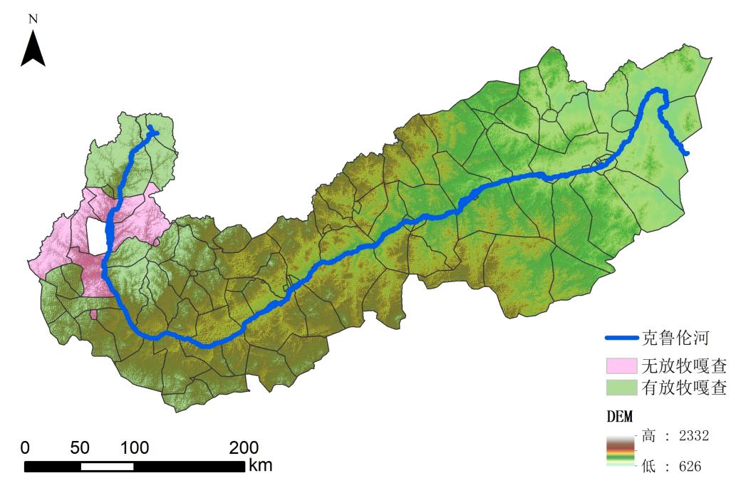
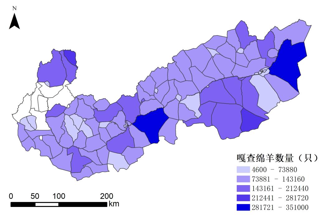
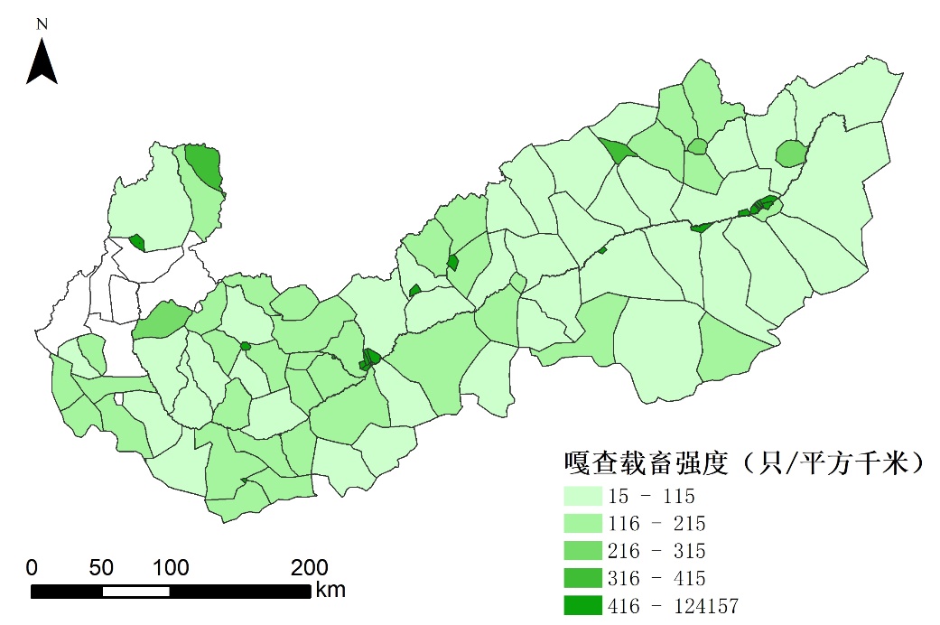
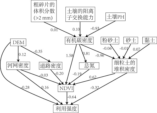
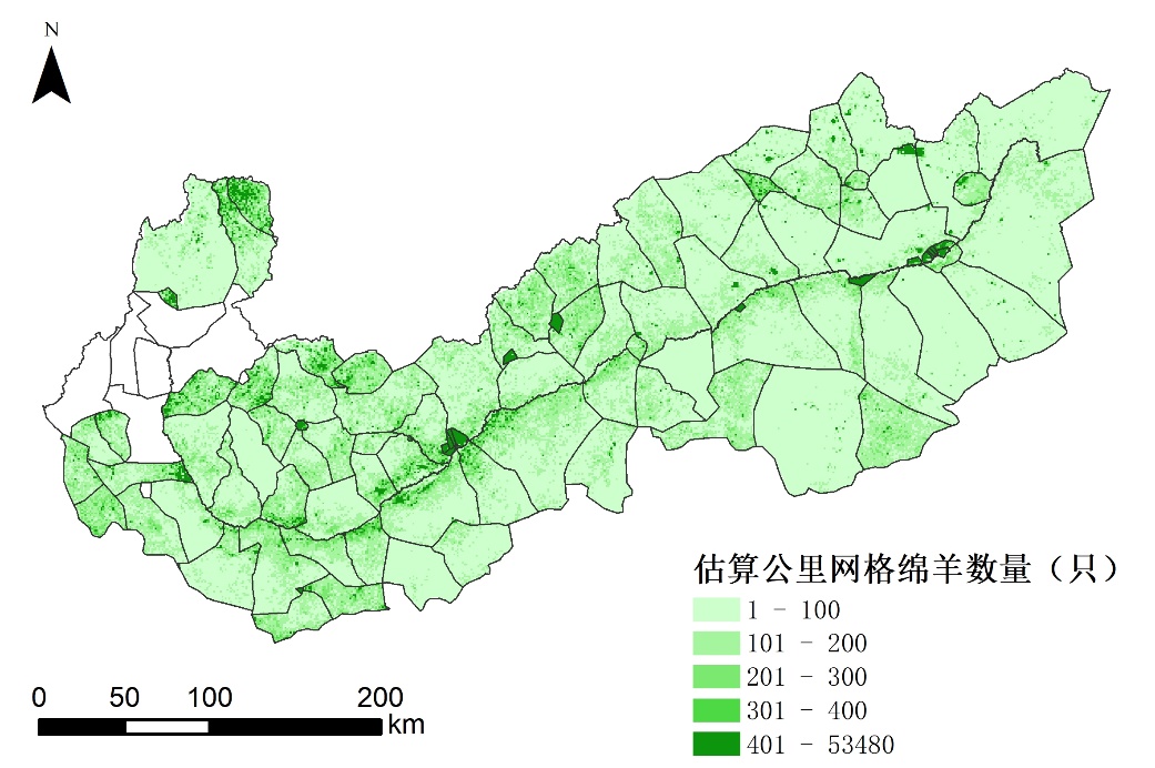
草原载畜强度是指单位面积上养殖的各类牲畜的数量,是评价草原生态状况和草原管理的重要指标。草原载畜强度过高可能导致草原退化、土壤侵蚀、生物多样性减少等一系列生态环境问题,研究估算草原载畜强度,并且指导合理的草原利用可以保持草原生态系统的可持续发展。传统估算草原载畜强度方式耗时耗力,难以直接估算放牧对草原载畜强度的影响。本数据集以放牧数量表示草原载畜强度作为研究对象,运用贝叶斯网络模型,考虑土壤属性、植被、地形、河网密度和道路密度等环境影响因素和2021年克鲁伦河流域113个嘎查的草原载畜强度之间的因果关系,估算克鲁伦河流域公里网格内的草原载畜强度。2021年克鲁伦河流域放牧马、骆驼、牛、山羊和绵羊共五种牲畜,经过换算后共有10821500只绵羊,分布在113个嘎查中,显示出显著的空间异质性。研究表明,地形高程(DEM)、河网密度、植被指数(NDVI)和细粒土堆积密度直接影响草原的载畜强度,其中NDVI的影响最为显著。草原载畜强度的预测结果显示,绵羊数量最多可达53480只,最少为0,平均每平方公里有115只。该模型完成了对草原载畜强度的准确预测,交叉验证中训练数据精度为84%,测试数据的精度为87%。

数据摘要:

项目 描述
数据库(集)名称 2021年克鲁伦河流域草原载畜强度数据集
所属学科 土地资源与信息技术
研究主题 草原载畜强度数据估算
数据时间范围 2021年
时间分辨率 1年
数据地理空间覆盖 克鲁伦河流域
空间分辨率 1千米
数据类型与技术格式 1 km高分辨率草原载畜强度分布(TIF格式)
数据库(集)组成 数据集为2021年克鲁伦河流域1km分辨率的草原载畜强度
数据量 1.04 MB
主要数据指标 克鲁伦河流域嘎查放牧牲畜数量、地形、NDVI、道路、河网、土壤属性数据
数据可用性 DOI:10.57760/sciencedb.agriculture.00110
CSTR:17058.11.sciencedb.agriculture.00110
经费支持 国家重点研发计划项目克鲁伦河流域面源污染遥感监测与评估技术研发(2021YFE0102300);国家自然科学基金项目(42271428)

关键词: 克鲁伦河流域, 贝叶斯网络, 载畜强度

Abstract:

Grassland Livestock Intensity(GLI) refers to the number of various types of livestock raised per unit area, and is an important indicator for evaluating the ecological status and management of grasslands. Excessive GLI may lead to a series of ecological and environmental problems, such as grassland degradation, soil erosion and biodiversity reduction, so research on estimating the GLI and guiding reasonable grassland use can maintain the sustainable development of grassland ecosystems. The traditional way of estimating GLI is time-consuming and labour-intensive, and it is difficult to directly estimate the effect of grazing on the GLI. In this study, we used the grazing quantity to indicate the GLI as the research object, and used a Bayesian network model to estimate the GLI within a kilometre grid in the Basin of Kherlen River by considering the causal relationship between environmental influences, such as soil properties, vegetation, topography, river network density and road density, and the GLI of the 113 bags in the Basin of Kherlen River in 2021. In 2021, five types of livestock, including horses, camels, cows, goats, and sheep, were grazed in the Basin of Kherlen River. After conversion, a total of 10821500 sheep were distributed among 113 bags, showing significant spatial heterogeneity. The study showed that topographic elevation (DEM), river network density, vegetation index (NDVI) and fine-grained soil accumulation density directly affected the GLI, with NDVI having the most significant effect. The prediction results of GLI showed that the maximum number of sheep could be up to 53,480 and the minimum was 0, with an average of 115 sheep per square kilometre. The model accomplished accurate prediction of GLI with an accuracy of 84% for the training data and 87% for the test data in cross-validation.

Data summary:

Items Description
Dataset name Grassland Livestock Intensity dataset for the Basin of Kherlen River in 2021
Specific subject area Land resources and information technology
Research topic Estimation of Grassland Livestock Intensity data
Time range 2021
Temporal resolution 1 year
Geographical scope the Basin of Kherlen River
Spatial resolution 1 kilometre
Data types and technical formats 1km high-resolution Grassland Livestock Intensity distribution (TIF format)
Dataset structure The dataset is the 1km resolution Grassland Livestock Intensity for the Basin of Kherlen River in 2021
Volume of dataset 1.04 MB
Key index in dataset Data on the number of grazing livestock, topography, NDVI, roads, river network, and soil attributes in the bags of Kherlen River Basin
Data accessibility DOI:10.57760/sciencedb.agriculture.00110;
CSTR:17058.11.sciencedb.agriculture.00110
Financial support Research and Development of Remote Sensing Monitoring and Assessment Technology for Surface Source Pollution in the Basin of Kherlen River under the National Key Research and Development Programme Project (2021YFE0102300); National Natural Science Foundation of China (42271428)

Key words: the Basin of Kherlen River, Bayesian network, livestock intensity