农业大数据学报 ›› 2025, Vol. 7 ›› Issue (1): 31-42.doi: 10.19788/j.issn.2096-6369.100027

• “一带一路”沿线农业资源环境监测与分析专栏 • 上一篇    下一篇

多源信息集成的2022年克鲁伦河流域草原型流域面源污染入河负荷空间分布数据集研制

谢成玉1(), 王辰怡2, 黄莉1, 高秉博2, 尹文杰1, SUKHBAATAR Chinzorig3, 王庆涛1, 陈华杰1, 冯权泷2, 李淑华4, 冯爱萍1,*()   

  1. 1.生态环境部卫星环境应用中心,北京 100094,中国
    2.中国农业大学土地科学与技术学院,北京 100083,中国
    3.蒙古科学院地理与生态地质研究所,乌兰巴托 15170,蒙古
    4.北京市农林科学院信息技术研究中心,北京 100097,中国
  • 收稿日期:2024-04-03 接受日期:2024-06-03 出版日期:2025-03-26 发布日期:2025-02-05
  • 通讯作者: 冯爱萍,E-mail:fengaiping1108@126.com
  • 作者简介:谢成玉,E-mail:xiecy_123@163.com
  • 基金资助:
    国家重点研发计划项目(2021YFE0102300)

Research of Spatial Distribution Dataset of Grassland-type Non- point Sources Pollution Loading to Rivers in the Kherlen River Basin in 2022 Integrated by Multi-source Information

XIE ChengYu1(), WANG ChenYi2, HUANG Li1, GAO BingBo2, YIN WenJie1, SUKHBAATAR Chinzorig3, WANG QingTao1, CHEN HuaJie1, FENG QuanLong2, LI ShuHua4, FENG AiPing1,*()   

  1. 1. Satellite Application Center for Ecology and Environment, Ministry of Ecology and Environment, Beijing, 100094, China
    2. College of land science and technology, China Agricultural University, Beijing, 100083, China
    3. Institute of Geography and Geoecology, Mongolian Academy of Sciences, Ulaanbaatar, 15170, Mongolia
    4. Research Center of Information Technology, Academy of Agriculture and Forestry Sciences, Beijing, 100097, China
  • Received:2024-04-03 Accepted:2024-06-03 Published:2025-03-26 Online:2025-02-05

摘要:

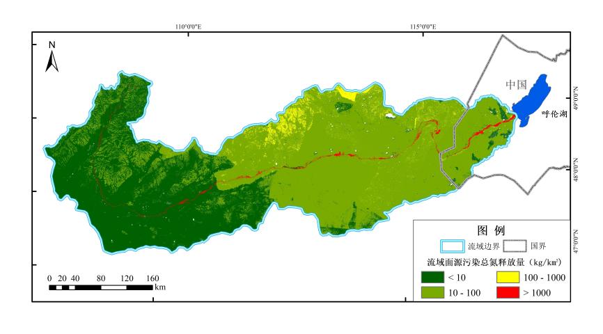
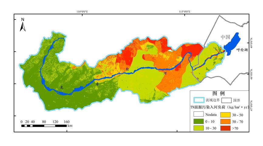
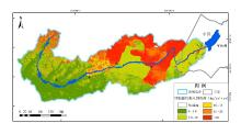
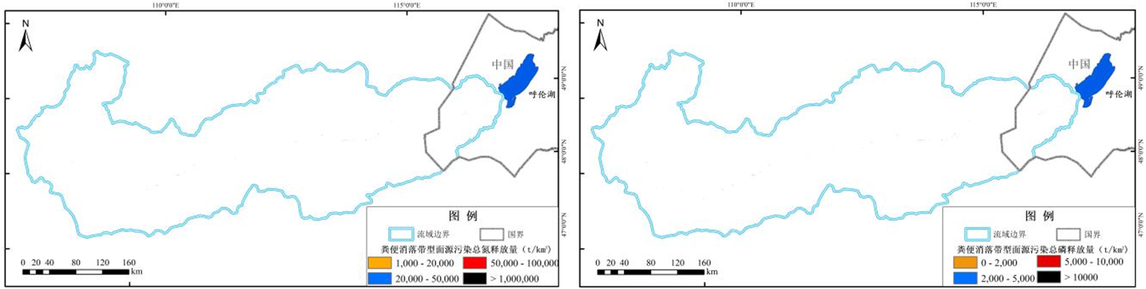
克鲁伦河流域位于“一带一路”沿线,共建绿色“一带一路”是“一带一路”顶层设计中的重要内容,保护流域的生态安全是中蒙两国面临的共同挑战和共同责任,因此理清克鲁伦河流域草原型流域面源(Non-point sources, NPS)污染入河负荷的空间分布,对于划分流域最优NPS污染空间管控单元至关重要。基于遥感分布式污染估算(DPeRS)模型,结合草原地表径流型和消落带型NPS污染特点研发草原型流域NPS污染入河负荷分布估算方法。该方法以遥感数据为驱动,实现了逐月尺度像元级NPS污染入河负荷分布估算,相较于以往NPS污染模拟模型,综合考虑了消落带型NPS污染对河流的影响。草原型流域NPS污染入河负荷由草原地表径流型NPS污染入河负荷和草原消落带型NPS污染入河负荷两部分组成。草原地表径流型NPS污染入河负荷分溶解态和颗粒态分别进行估算,主要基于克鲁伦河流域干湿沉降、土壤、草原利用强度等地面数据及遥感数据核算草地氮磷平衡,结合流域降水、土壤氮磷含量等草原型NPS污染连续型参数的空间分布特征,耦合定量遥感反演模型与NPS污染地面模型开展空间负荷估算;草原消落带型NPS污染入河负荷则是基于2019—2022年4—10月逐月哨兵2号影像提取的流域消落带范围,结合消落带不同地类土柱淹没释放模拟实验获取的NPS污染总氮和总磷释放速率,估算草原消落带型NPS污染负荷量。基于以上方法最终得到克鲁伦河流域草原型流域NPS污染入河负荷空间分布数据集,并统计得出2022年流域NPS污染总氮和总磷入河量分别为3542.5 t/yr和1559.9 t/yr,其中地表径流型NPS污染总氮和总磷入河量分别为3105.0 t/yr和1387.1 t/yr,消落带型NPS污染总氮和总磷入河量分别为437.5 t/yr和172.8 t/yr。本数据集为实现高精度的流域NPS污染管控单元划分技术提供了有力支撑,对于中蒙两国维护“一带一路”沿线的资源生态安全具有重要的参考意义。

数据摘要:

项目 描述
数据库(集)名称 多源信息集成的2022年克鲁伦河流域草原型流域面源污染入河负荷空间分布数据集
所属学科 土地资源与信息技术
研究主题 克鲁伦河流域草原型流域面源污染入河负荷模拟
数据时间范围 2022年
时间分辨率
数据地理空间覆盖 克鲁伦河流域
空间分辨率 30 m
数据类型与技术格式
30 m草原型流域面源污染总磷入河负荷(TIF格式)
30 m草原型流域面源污染总氮入河负荷(TIF格式)
数据库(集)组成 数据集为2022年克鲁伦河流域30m空间分辨率草原型流域面源污染总氮总磷入河负荷量
数据量 2.73 GB
主要数据指标 克鲁伦河流域草原型流域面源污染总磷入河负荷量、克鲁伦河流域草原型流域面源污染总氮入河负荷量
数据可用性
https://cstr.cn/17058.11.sciencedb.agriculture.00114
https://doi.org/10.57760/sciencedb.agriculture.00114
经费支持 国家重点研发计划项目克鲁伦河流域面源污染遥感监测与评估技术研发(2021YFE0102300)

关键词: 克鲁伦河流域, 草原型流域面源污染, 入河负荷, 地表径流型面源污染, 消落带型面源污染

Abstract:

The Kherlen River Basin is located along the Silk Road, and jointly building a green road is an important part of the top-level design of the Silk Road. China and Mongolia face the common challenge and responsibility of protecting the ecological security of the basin. Therefore, it is important to clarify the spatial distribution of grassland-type load estimation of non-point sources (NPS) pollution into the Kherlen River Basin, which is essential for the division of the optimal spatial control unit of NPS pollution in the basin. On the basis of Chinese self-developed DPeRS (Diffuse Pollution estimation with Remote Sensing) model, this paper has developed a method for estimating the grassland-type load distribution of NPS pollution into river in the basin, by combining the NPS pollution characteristics of surface runoff on grassland and incorporating the spatial distribution of NPS pollution loads in hydro-fluctuation zone. The method is driven by remote sensing data, and it can realize the distribution of NPS pollution load estimation into river at the pixel level month by month. Compared to the previous NPS pollution simulation models, this method comprehensively takes into account the impact of hydro-fluctuation zone NPS pollution on rivers. The grassland-type load estimation of NPS pollution is composed of two parts: the NPS pollution of surface runoff on grassland and the NPS pollution of hydro-fluctuation zone on grassland. The NPS pollution load of surface runoff on grassland into the river is mainly estimated from the dissolved state and erosion particle state. Firstly, the nitrogen and phosphorus balance of grassland was calculated based on ground data (such as wet and dry deposition data, soil data, grassland utilization intensity) and remote sensing data in the Kherlen River Basin. Then, space load estimation is carried out by coupling a quantitative remote sensing inversion model with the ground model of NPS pollution, by combining the spatial distribution characteristics of continuous parameters in estimating the grassland-type NPS pollution, such as precipitation in the watershed, soil nitrogen and phosphorus content. Grassland NPS pollution loads in hydro-fluctuation zone is estimated based on the extent of hydro-fluctuation zone extracted from month-by-month Sentinel 2 imagery from April-October, 2019-2022. And the volume of grassland-type NPS pollution loads in the hydro-fluctuation zone is calculated by the release rates of NPS pollution total nitrogen and total phosphorus obtained from submerged release simulation experiments of soil columns in different land use type in the hydro-fluctuation zone. Based on above methods, the spatial distribution dataset of grassland-type NPS pollution load into river is finally obtained. And the NPS pollution load of total nitrogen and total phosphorus into river is 3542.5 t/yr and 1559.9 t/yr in 2022, respectively. The total nitrogen and phosphorus of surface runoff type NPS into the river were 3105.0 t/yr and 1387.1 t/yr, respectively. The total nitrogen and phosphorus of hydro-fluctuation zone type NPS into the river were 437.5 t/yr and 172.8 t/yr, respectively. This dataset provides a strong support for the realization of high-precision division technology of NPS pollution control unit, which is of great reference significance for China and Mongolia to maintain the resource and ecological security along the Silk Road.

Data summary:

Item Description
Dataset name Research of Spatial Distribution Dataset of Grassland-type Non-point Sources Pollution Loading to Rivers in the Kherlen River Basin in 2022 Integrated by Multi-source Information
Specific subject area Land resources and information technology
Research topic Grassland-type (NPS) pollution loading to rivers in the Kherlen River Basin
Time range 2022 year
Temporal resolution No
Geographical scope Kherlen River basin
Spatial resolution 30 meter
Data types and technical formats Grassland-type NPS pollution of total phosphorus loading to rivers in the Kherlen River Basin with 30 m resolution (TIF format)
Grassland-type NPS pollution of total nitrogen loading to rivers in the Kherlen River Basin with 30 m resolution (TIF format)
Dataset structure The dataset is 2022 grassland-type NPS pollution of total phosphorus and total nitrogen loading to rivers in the Kherlen River Basin with 30 m resolution
Volume of dataset 2.73 GB
Key index in dataset Grassland-type NPS pollution of total phosphorus loading to rivers in the Kherlen River Basin
Grassland-type NPS pollution of total nitrogen loading to rivers in the Kherlen River Basin
Data accessibility https://cstr.cn/17058.11.sciencedb.agriculture.00114
https://doi.org/10.57760/sciencedb.agriculture.00114
Financial support Research and development on remote sensing monitoring and assessment technology of non-point source pollution in Kherlen River Basin under the national key research and development program(2021YFE0102300)

Key words: Kherlen River Basin, grassland-type NPS pollution of basin, loads into river, NPS pollution of surface runoff, NPS pollution of hydro-fluctuation zone