
Journal of Agricultural Big Data ›› 2026, Vol. 8 ›› Issue (3): 281-295.doi: 10.19788/j.issn.2096-6369.000161
WANG ZhengFeng1( ), LI Li2, MA RuiSheng3, MO YunJie4, KUANG ZhaoMin3,*()
Received:2026-04-26
Accepted:2026-07-15
Online:2026-09-26
Published:2026-10-08
Contact:
KUANG ZhaoMin
WANG ZhengFeng, LI Li, MA RuiSheng, MO YunJie, KUANG ZhaoMin. Research on a Low-Altitude Remote Sensing Segmentation Model for Sugarcane Drought Level Identification[J].Journal of Agricultural Big Data, 2026, 8(3): 281-295.
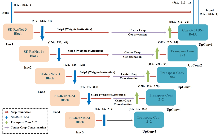
Fig. 1
Schematic diagram of the CaneUNet-W model structure"
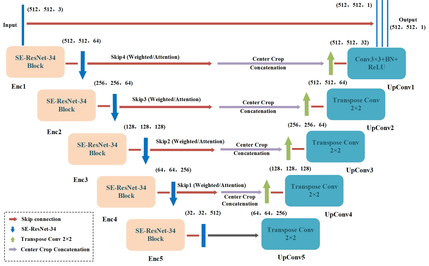
Table 1
Model structure parameter settings (example for input image size 512×512)"
| 模块 | 名称 | 操作类型 | 输出尺寸(H×W×C) | 参数说明 |
|---|---|---|---|---|
| 编码器 | Enc1 | Conv3×3+BN+ReLU×2 | 512×512×64 | ResNet-34 第1层 |
| Enc2 | Conv3×3+BN+ReLU×2 | 256×256×64 | MaxPool + ResNet-34 第2层 | |
| Enc3 | Conv3×3+BN+ReLU×2 | 128×128×128 | ResNet-34 第3层 | |
| Enc4 | Conv3×3+BN+ReLU×2 | 64×64×256 | ResNet-34 第4层 | |
| Enc5 | Conv3×3+BN+ReLU×2 | 32×32×512 | ResNet-34 第5层 | |
| 解码器 | UpConv5 | Transposed Conv 2×2 | 64×64×256 | 与 Enc4 特征相加融合 |
| UpConv4 | Transposed Conv 2×2 | 128×128×128 | 与 Enc3 特征相加融合 | |
| UpConv3 | Transposed Conv 2×2 | 256×256×64 | 与 Enc2 特征相加融合 | |
| UpConv2 | Transposed Conv 2×2 | 512×512×64 | 与 Enc1 特征相加融合 | |
| UpConv1 | Conv3×3+BN+ReLU | 512×512×32 | 最后融合层 | |
| 输出层 | OutputConv | Conv1×1+Sigmoid | 512×512×1 | 二分类概率图(甘蔗/非甘蔗)输出 |
Table 2
Drought classification standards"
| 干旱等级 | NDVI阈值区间 | 作物状态描述 |
|---|---|---|
| Level 0 | NDVI>0.70 | 无明显缺水迹象 |
| Level 1 | 0.50≤NDVI≤0.70 | 轻度水分不足,叶片色泽略暗 |
| Level 2 | 0.35≤NDVI<0.50 | 明显干旱,叶片卷曲发黄 |
| Level 3 | 0.20≤NDVI<0.35 | 重度干旱,叶片明显干枯 |
| Level 4 | NDVI<0.20 | 严重干旱,生长停滞或枯死 |
Table 3
Regional crossover experimental design plan"
| 实验编号 | 训练区域 | 测试区域 |
|---|---|---|
| 实验一 | A区+B区 | C区 |
| 实验二 | B区+C区 | A区 |
| 实验三 | A区+C区 | B区 |
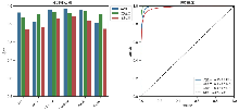
Fig. 2
Performance evaluation results of the model in the three-region cross-validation experiments. Evaluation metrics include IoU, mIoU, F1-score, Precision, Recall, and Kappa coefficient. Each experiment used data from two regions to train the model and tested it in the remaining regions. Subplots: Left (Grouped bar charts) show the scores of each metric; Right (ROC curves) show the classification performance and AUC value."
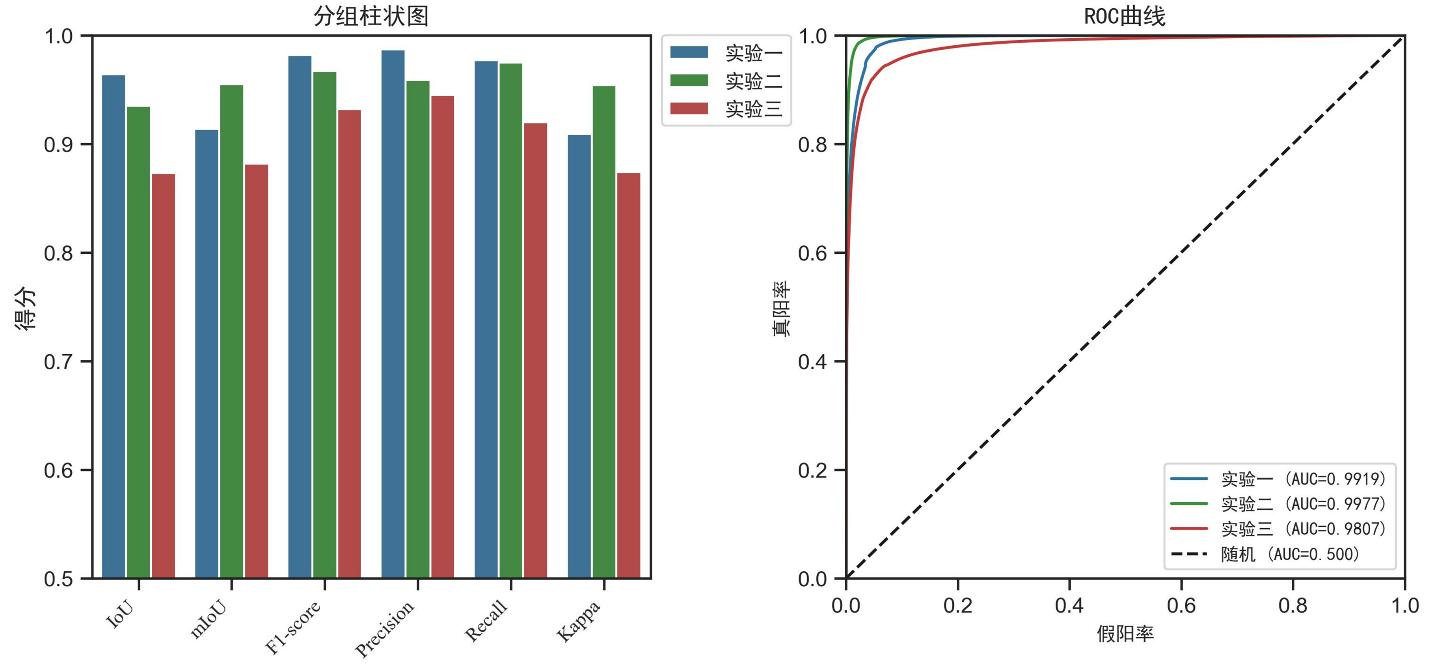
Table 4
Model performance evaluation metrics in different test areas"
| 实验编号 | IoU | mIoU | F1-score | Precision | Recall | Kappa |
|---|---|---|---|---|---|---|
| 实验一 | 0.964 | 0.914 | 0.982 | 0.987 | 0.977 | 0.909 |
| 实验二 | 0.935 | 0.955 | 0.967 | 0.959 | 0.975 | 0.954 |
| 实验三 | 0.873 | 0.882 | 0.932 | 0.945 | 0.920 | 0.874 |
Fig. 3
Study area distribution and experimental performance comparison: The geographical locations and model performance of the three experimental areas are marked. Area A performed best (mIoU=0.955, Kappa=0.954), Area B performed relatively poorly (mIoU=0.882, Kappa=0.874), and Area C, with its flat terrain and later data collection time, had slightly lower mIoU and Kappa. The figure visually illustrates the impact of topographic and phenological differences on the model's recognition accuracy."
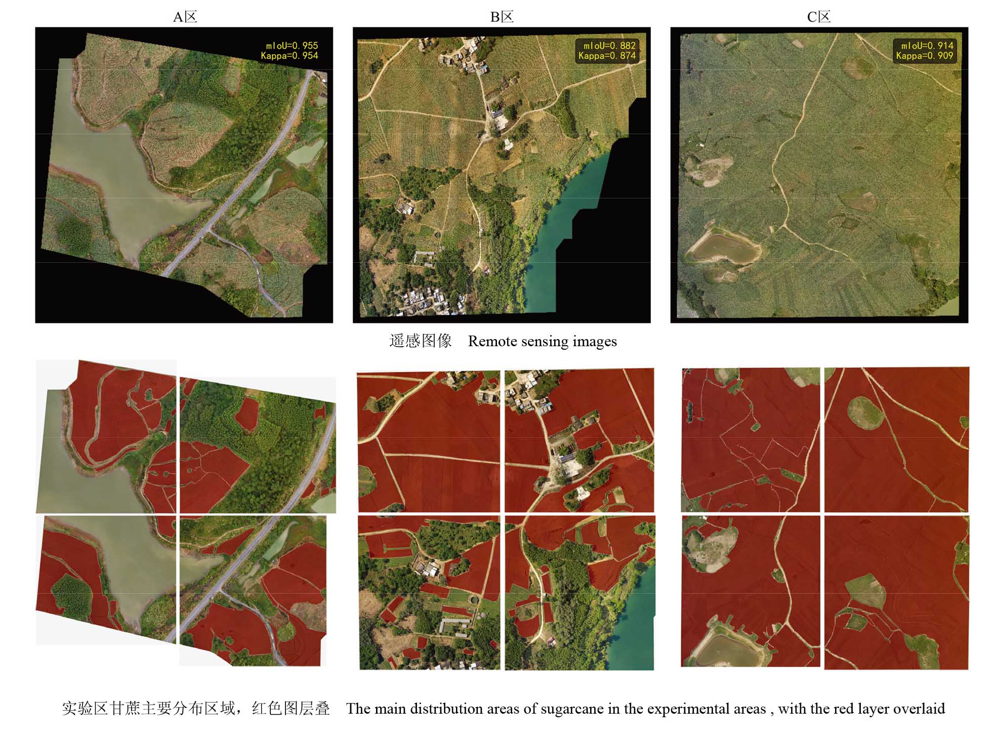
Fig. 4
Visual example of sugarcane field segmentation and drought level prediction in a typical test area. The left column shows the original UAV imagery, the middle column shows the predicted drought levels, and the right column shows the overlay results, which intuitively demonstrate the model's accurate identification of sugarcane field edges and the objective and refined characterization of drought spatial conditions using the NDVI physical index."
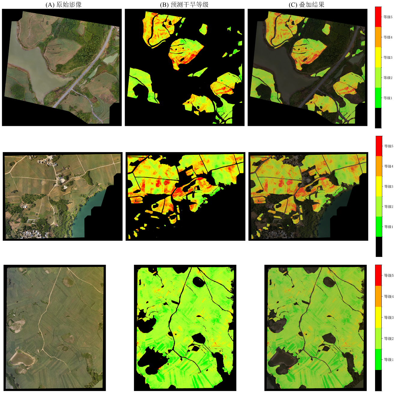
Table 5
Performance comparison of different models in sugarcane field recognition tasks"
| 模型 | IoU | mIoU | F1-score | Precision | Recall | Kappa | Time (s) |
|---|---|---|---|---|---|---|---|
| U-Net | 0.814 | 0.683 | 0.898 | 0.988 | 0.822 | 0.618 | 18.24 |
| DeepLabv3+ | 0.969 | 0.925 | 0.984 | 0.987 | 0.982 | 0.921 | 21.99 |
| CaneUNet-W | 0.970 | 0.926 | 0.985 | 0.983 | 0.987 | 0.923 | 11.55 |
Fig. 5
compares the CaneUNet-W model with other models on various metrics and evaluates the overall performance of the three models. Evaluation metrics include IoU, mIoU, F1-score, Precision, Recall, and Kappa coefficient. The left figure shows the specific values of the three models on each metric and the overall performance differences; The right figure shows the ROC curves of the three models' classification performance and AUC values."
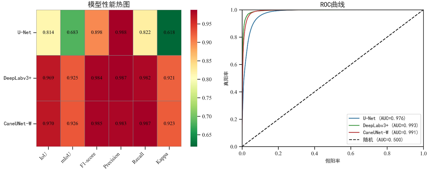
Fig. 6
Comparison of model performance evaluation and ablation experiment results. Performance analysis of five ablation models of the improved U-Net model on various evaluation metrics (IoU, mIoU, F1-score, Precision, Recall, Kappa). The left figure (Violin-box-means plot) shows the value distribution, dispersion, and mean comparison of each model on all metrics; The right figure (ROC curve plot) shows the classification performance of the five models and their corresponding AUC values."
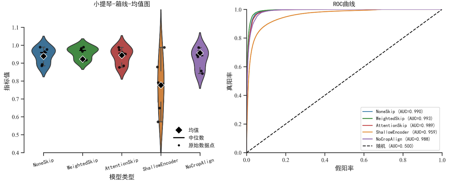
Table 6
Comparison of ablation experiment results"
| 模型版本 | IoU | mIoU | F1-score | Precision | Recall | Kappa |
|---|---|---|---|---|---|---|
| 无skip(NoneSkip) | 0.954 | 0.893 | 0.976 | 0.989 | 0.964 | 0.885 |
| 加权skip(WeightedSkip) | 0.965 | 0.917 | 0.982 | 0.989 | 0.976 | 0.912 |
| 注意力skip(AttentionSkip) | 0.950 | 0.885 | 0.974 | 0.988 | 0.961 | 0.876 |
| 浅层编码器(ShallowEncoder) | 0.783 | 0.649 | 0.878 | 0.988 | 0.791 | 0.572 |
| 无中心裁剪对齐(NoCropAlign) | 0.935 | 0.856 | 0.967 | 0.987 | 0.947 | 0.842 |
| [1] |
Sharma H, Sidhu H, Bhowmik A. Remote sensing using unmanned aerial vehicles for water stress detection: a review focusing on specialty crops. Drones, 2025, 9(4): 241.
doi: 10.3390/drones9040241 |
| [2] |
Chen H, Yang N, Song X, et al. A novel agricultural drought index based on multi-source remote sensing data and interpretable machine learning. Agricultural Water Management, 2025, 308: 109303.
doi: 10.1016/j.agwat.2025.109303 |
| [3] | 李欣璋, 别强, 石莹, 等. 中国西北地区不同类型草地NDVI对SPEI 的时空响应特征[J/OL]. 甘肃农业大学学报(2025-12-03). https://link.cnki.net/urlid/62.1055.s.20251202.2007.008. |
| Li X Z, Bie Q, Shi Y, et al. Spatiotemporal response characteristics of NDVI to SPEI in different grassland types in Northwest China[J/OL]. Journal of Gansu Agricultural University (2025-12-03). https://link.cnki.net/urlid/62.1055.s.20251202.2007.008. | |
| [4] |
Mullapudi A, Vibhute A D, Mali S, et al. A review of agricultural drought assessment with remote sensing data: Methods, issues, challenges and opportunities. Applied Geomatics, 2023, 15(1): 1-13.
doi: 10.1007/s12518-022-00484-6 |
| [5] |
Som-Ard J, Atzberger C, Izquierdo-Verdiguier E, et al. Remote sensing applications in sugarcane cultivation: A review. Remote Sensing, 2021, 13(20): 4040.
doi: 10.3390/rs13204040 |
| [6] | 李莉, 匡昭敏, 莫建飞, 等. 广西甘蔗秋旱灾害风险评估技术初步研究. 应用气象学报, 2016, 27(1): 95-101. |
| Li L, Kuang Z M, Mo J F, et al. Assessment of autumn drought risk of sugarcane in Guangxi. Journal of Applied Meteorological Science, 2016, 27(1): 95-101. | |
| [7] |
Kumar V, Sharma K V, Pham Q B, et al. Advancements in drought using remote sensing: assessing progress, overcoming challenges, and exploring future opportunities. Theoretical and Applied Climatology, 2024, 155(6): 4251-4288.
doi: 10.1007/s00704-024-04914-w |
| [8] |
Awais M, Li W, Cheema M J M, et al. UAV-based remote sensing in plant stress imagine using high-resolution thermal sensor for digital agriculture practices: A meta-review. International Journal of Environmental Science and Technology, 2023, 20(1): 1135-1152.
doi: 10.1007/s13762-021-03801-5 |
| [9] | 李林源, 黄华国, 穆西晗, 等. 低空无人机植被定量遥感:进展、挑战与展望. 遥感学报, 2025, 29(6): 2083-2113. |
|
Li L Y, Huang H G, Mu X H, et al. Low-altitude UAV-based quantitative remote sensing of vegetation: Advances, challenges, and prospects. National Remote Sensing Bulletin, 2025, 29(6): 2083-2113.
doi: 10.11834/jrs.20255048 |
|
| [10] | Mohd Nazri N W, Hashim K A, Mohd Zaki N A, et al. Advancing sustainable paddy farming: utilizing multispectral unmanned aerial vehicle (UAV) technology for efficient water stress detection and management//2025 21st IEEE International Colloquium on Signal Processing & Its Applications (CSPA). February 7-8, 2025: 210-215. |
| [11] | Aldrighettoni J, d'Urso M G. Advances in precision farming: a contribute for estimating crop health and water stress by comparing UAV multispectral and thermal imagery. ISPRS Annals of the Photogrammetry, Remote Sensing and Spatial Information Sciences, 2025: 33-40. |
| [12] |
Ahmad U, Alvino A, Marino S. A review of crop water stress assessment using remote sensing. Remote Sensing, 2021, 13(20): 4155.
doi: 10.3390/rs13204155 |
| [13] |
Ruwanpathirana P P, Sakai K, Jayasinghe G Y, et al. Evaluation of sugarcane crop growth monitoring using vegetation indices derived from RGB-based UAV images and machine learning models. Agronomy, 2024, 14(9): 2059.
doi: 10.3390/agronomy14092059 |
| [14] |
Dong H, Dong J H, Sun S K, et al. Crop water stress detection based on UAV remote sensing systems. Agricultural Water Management, 2024, 303: 109059.
doi: 10.1016/j.agwat.2024.109059 |
| [15] |
钱涛, 詹雅婷, 李胤, 等. 基于车载相机和HLS时序遥感数据的作物分类研究. 农业大数据学报, 2025, 7(2): 161-172.
doi: 10.19788/j.issn.2096-6369.000098 |
|
Qian T, Zhan Y T, Li Y, et al. Crop Classification research based on vehicle images and HLS time-series remote sensing data. Journal of Agricultural Big Data, 2025, 7(2): 161-172.
doi: 10.19788/j.issn.2096-6369.000098 |
|
| [16] |
Cai Z R, Liu Z Y, Kou L. Reliable UAV monitoring system using deep learning approaches. IEEE Transactions on Reliability, 2022, 71(2): 973-983.
doi: 10.1109/TR.2021.3119068 |
| [17] |
Bouguettaya A, Zarzour H, Kechida A, et al. Deep learning techniques to classify agricultural crops through UAV imagery: A review. Neural Computing and Applications, 2022, 34(12): 9511-9536.
doi: 10.1007/s00521-022-07104-9 |
| [18] |
Mittal P, Singh R, Sharma A. Deep learning-based object detection in low-altitude UAV datasets: A survey. Image and Vision Computing, 2020, 104: 104046.
doi: 10.1016/j.imavis.2020.104046 |
| [19] | 黄睿茜, 赵俊芳, 霍治国, 等. 深度学习技术在农业干旱监测预测及风险评估中的应用. 中国农业气象, 2023, 44(10): 943-952. |
| Huang R X, Zhao J F, Huo Z G, et al. Application of deep learning technology in monitoring,forecasting and risk assessment of agricultural drought. Chinese Journal of Agrometeorology, 2023, 44(10): 943-952. | |
| [20] |
苑江浩, 郑作军, 初昌明, 等. 2023年黑龙江水稻产量预测无人机遥感图像数据集. 农业大数据学报, 2024, 6(4): 546-551.
doi: 10.19788/j.issn.2096-6369.100031 |
|
Yuan J H, Zheng Z J, Chu C M, et al.Rice yield prediction UAV remote sensing image dataset of Heilongjiang province in 2023. Journal of Agricultural Big Data, 2024, 6(4): 546-551
doi: 10.19788/j.issn.2096-6369.100031 |
|
| [21] |
Osco L P, Junior J M, Ramos A P M, et al. A review on deep learning in UAV remote sensing. International Journal of Applied Earth Observation and Geoinformation, 2021, 102: 102456.
doi: 10.1016/j.jag.2021.102456 |
| [22] |
Shahi T B, Xu C Y, Neupane A, et al. Recent advances in crop disease detection using UAV and deep learning techniques. Remote Sensing, 2023, 15(9): 2450.
doi: 10.3390/rs15092450 |
| [23] |
Su J Y, Coombes M, Liu C J, et al. Machine learning-based crop drought mapping system by UAV remote sensing RGB imagery. Unmanned Systems, 2020, 8(1): 71-83.
doi: 10.1142/S2301385020500053 |
| [24] |
Prodhan F A, Zhang J, Yao F, et al. Deep learning for monitoring agricultural drought in south Asia using remote sensing data. Remote Sensing, 2021, 13(9): 1715.
doi: 10.3390/rs13091715 |
| [25] |
Yang X H, Gao F, Yuan H W, et al. Integrated UAV and satellite multi-spectral for agricultural drought monitoring of winter wheat in the seedling stage. Sensors, 2024, 24(17): 5715.
doi: 10.3390/s24175715 |
| [26] |
Liu C, Li H Y, Su A Y, et al. Identification and grading of maize drought on RGB images of UAV based on improved U-Net. IEEE Geoscience and Remote Sensing Letters, 2021, 18(2): 198-202.
doi: 10.1109/LGRS.8859 |
| [27] | 张淦, 严海峰, 胡根生, 等. 基于深度学习语义分割和迁移学习策略的麦田倒伏面积识别方法. 智慧农业(中英文), 2023, 5(3): 75-85. |
|
Zhang G, Yan H F, Hu G S, et al. Identification method of wheat field lodging area based on deep learning semantic segmentation and transfer learning. Smart Agriculture, 2023, 5(3): 75-85.
doi: 10.12133/j.smartag.SA202309013 |
|
| [28] |
Liang H, Zhou Y, Lu Y, et al. Evaluation of soybean drought tolerance using multimodal data from an unmanned aerial vehicle and machine learning. Remote Sensing, 2024, 16(11): 2043.
doi: 10.3390/rs16112043 |
| [29] |
Niu S W, Nie Z G, Li G, et al. Early drought detection in maize using UAV images and YOLOv8+. Drones, 2024, 8(5): 170.
doi: 10.3390/drones8050170 |
| [30] |
Zhou J, Zhou J F, Ye H, et al. Classification of soybean leaf wilting due to drought stress using UAV-based imagery. Computers and Electronics in Agriculture, 2020, 175: 105576.
doi: 10.1016/j.compag.2020.105576 |
| [1] | CHEN Shi, HUANG YinLan, ZOU JinQiu. Spatial Distribution Dataset of Winter Fallow Fields in the Wanjiang Plain (2019-2024) [J]. Journal of Agricultural Big Data, 2026, 8(2): 274-280. |
| [2] | XIAO YinFeng, YANG Shu. AGLU-YOLO: Research on Real-time Detection Algorithm of Lightweight Citrus Leaf Disease [J]. Journal of Agricultural Big Data, 2026, 8(2): 141-154. |
| [3] | ZHAO XiaoYan, ZHOU HuanBin, ZHOU GuoMin, ZHANG JianHua. Application of Deep Learning in Crop Gene Editing Technology and Research Progress [J]. Journal of Agricultural Big Data, 2026, 8(1): 24-35. |
| [4] | YE DuanNan, LI GenTian. A Small Object Detection Model Based on Improved YOLO [J]. Journal of Agricultural Big Data, 2025, 7(2): 173-182. |
| [5] | LIU Hong, DOU JingWen, WANG Yue, LIAO Yong, LIU XiaoLei, LI XinYun, ZHAO ShuHong, FU YuHua. A Multi-Omics Dataset for Functional Gene Mining in Animals [J]. Journal of Agricultural Big Data, 2025, 7(1): 96-106. |
| [6] | NIU BoWen, FENG QuanLong, ZHANG Yu, GAO BingBo, SUKHBAATAR Chinzorig, FENG AiPing, YANG JianYu. A 10-m Fractional Vegetation Cover Monthly Dataset of the Kherlen River Basin in 2022 [J]. Journal of Agricultural Big Data, 2025, 7(1): 59-68. |
| [7] | LI JiaLe, ZHANG JianHua, WANG Jian, ZHOU GuoMin. Metrological Analysis of Data-driven Deep Learning Methods for Agriculture [J]. Journal of Agricultural Big Data, 2024, 6(3): 400-411. |
| [8] | DU JiaKuan, LI YanFei, SUN SiWen, LIU JiDong, JIANG TengDa. Pan-spatiotemporal Feature Rice Deep Learning Extraction Based on Multi-source Data Fusion [J]. Journal of Agricultural Big Data, 2024, 6(1): 56-67. |
| [9] | MAO KeBiao, YUAN ZiJin, SHI JianCheng, WU ShengLi, HU DeYong, CHE Jin, DONG LiXin. Theory and Engineering Technology Implementation of Artificial Intelligence Retrieval Paradigm for Parameters of Remote Sensing Based on Big Data [J]. Journal of Agricultural Big Data, 2023, 5(4): 1-12. |
| [10] | ZHAO HongXin, SHAO MingYue, PAN Pan, WANG ZhiAo, MU Qiang, HE ZiKang, ZHANG JianHua. A Training Dataset for Deep Neural Network Model Recognition of Common Cotton Diseases [J]. Journal of Agricultural Big Data, 2023, 5(4): 47-55. |
| [11] | Lingxu Zhang,Rui Han,Wenming Li,Yinxue Shi,Chi Liu. A Survey of Big Data Deep Learning Systems and a Typical Agricultural Application [J]. Journal of Agricultural Big Data, 2019, 1(2): 88-104. |
| [12] | Lei Wu,Xiaohe Liang,Jisiguleng Wu,Rui Wang. Method and Agricultural Empirical Study of Query Reformulation Based on Word Embedding [J]. Journal of Agricultural Big Data, 2019, 1(2): 114-120. |
| [13] | Li Xianjiang, Chen Youqi, Zou Jinqiu, Shi Shuqin, Guo Tao, Cai Weimin, Chen Hao. Application of Convolutional Neural Networks in High-Resolution Image Classification [J]. Journal of Agricultural Big Data, 2019, 1(1): 67-77. |
|
||